Public access on Lake Norman has been a main priority since the inception of the lake. Today, there are ten public access areas to the lake, primarily for boating access. To gain further knowledge of the amenities available, view the map above.
Change in public access over time
Duke Power was required by the Federal Energy Regulatory Commission (FERC) to provide six access points by law. Many accounts have noted that Lake Norman has consistently had ten public access points since 1964, however some have cited eight. The reason, we speculate, for the discrepancy in the numbers is perhaps that Duke either (a) provided four extra public access points or (b) provided two extra public access points and then an additional two were added by outside parties. Either way, Duke exceeded the FERC requirements.
Further, there seems to have been an interesting reduction in public access land over the years. Accounts from the 1980s report access areas situated upon acres of land, everywhere from 4 to 47 (with the exception of the State Park’s 1,600). However, recent looks at the different areas show what appears to be significant reductions in space. No longer are there evidently sprawling acres of land surrounding the boat ramps and access points. Instead, the locations primarily consist of small parking lots with access to boat ramps. We have to speculate that within the 20 to 30 years since this account, there has been an increase in development and thus a resulting decrease in public access acreage.
How “accessible” is the access?
In thinking of access, we framed it in two ways: “who has access” and “who wants access.” Technically, by looking at the map it is evident that people can access the lake from many surrounding locations, thanks to the ten different points. Most of the access points do not have gates or entrance fees. Further, the park itself never closes entirely because of the communities located in areas encompassed by the park. In this sense, the lake would not be considered inaccessible.
However, it is the latter question that challenges the notion of accessibility. By referencing the map above, we can see that the only area available for public swimming is Lake Norman State Park. Aside from other recreational land activities at some of the other locations, the only access that the public can have to the lake at the nine other areas is with a boat. This dramatically limits the scope of “public” by circumscribing it to those with access to boats. Anyone interested in swimming or other water activities are restricted to the State Park alone. And if we return to the first question, who has access, we now have a completely different answer. Due to the remote location of the park, access is severely limited to the public. The state park is located at the northern point of the lake while Charlotte, the most densely populated part of the area, is located south of the lake. Only those with access to cars can really enjoy the recreational activities and educational opportunities provided by the park. (Note: we speculate the park is located there for developmental reasons: when Duke was selling and developing land, this was most likely considered the least valuable due to its secluded location. Even today, Iredell County remains less developed than the other counties around the lake). While the state park is a great resource for people who want to enjoy nature and provides access to Lake Norman as a whole, we wonder if it can properly serve the needs of the Lake Norman community because of its physical distance from people.
Demand for more access
For years, the local communities have requested more public access to the lake. Recently, Mecklenburg County has made plans to develop Jetton Park. Unfortunately, it is unlikely that swimming will ever be permitted outside of the park but one goal for the future will be more allocation of land for public access.
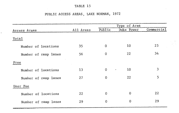
from Lake Norman Developmental Impact Study, June 1972, page 59
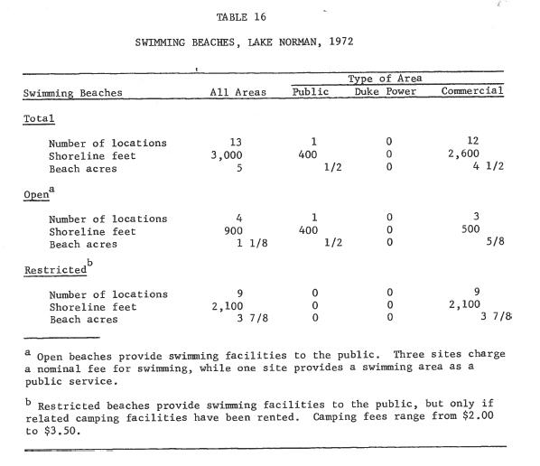
from Lake Norman Developmental Impact Study, June 1972, page 57