1976-1987
Development Plans
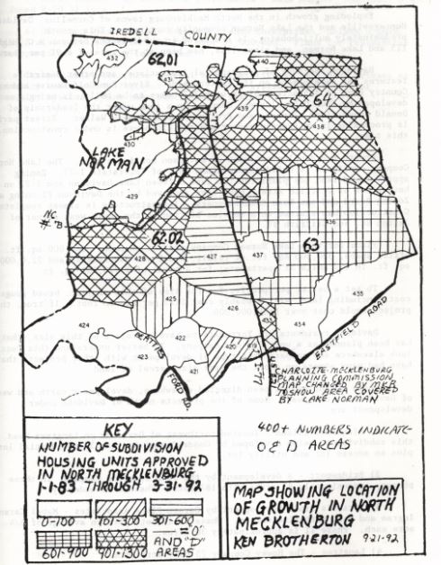
The heaviest concentration of growth occurred around Lake Norman in areas 428, with 1650 units, 429 with 1,211 units, and area 431 with 1,056 units.
After the lake was filled with water in 1963, population trends changed in the Lake Norman area. Slow development soon ensued such as zoning, county and municipal land use. On October 28, 1976 The Town of Davidson Zoning and Subdivision Ordinance was established, followed by Cornelius in 1977. Iredell County established preliminary zoning on land that drained into Lake Norman in order to ensure that the lake be kept pure and clean. As a result some land units in Iredell’s land bordering Lake Norman have yet to exercise their land use authority.
Land use development plans around Lake Norman were primarily formed to ensure that the water be kept pure. Plans, however, did not incorporate lakefront parks as opposed to housing units, an element that would have widened access to the use of the lake to a larger population. Mecklenburg County did, however, purchase land to establish two waterfront parks located west of NC Highway No. 73 southwest of Cornelius, N.C.
In 1985 there was an update to The 2005 Generalized Land Use Plan for Charlotte-Mecklenburg, a plan whose primary objective was to promote balanced growth in the area since it was noted that populations were concentrated in the eastern and southern part of the county. In 1984-85 a committee was formed to commission a land-use plan for Mecklenburg County where they divided seven planning areas. Eight categories of development took place after the lake’s introduction: Resort residential, urban residential, agricultural residential, access areas, commercial access areas, commercial, industrial and flood plains. The objective of this committee was to develop plans for the area and strategies for its growth through the year 2005. With this development plan in place, population growth results were apparent by 1988.
In 1985-1987 the Mecklenburg 20 Year County Land Use Plan was reviewed and modified to direct growth into northern Mecklenburg County via infrastructure and zoning. Towards the end of 1988 population curves increased so that the 1990 census count was 22,220 with 87.5% of its population being Caucasian. The heaviest concentrations of growth took place on the peripheries of Lake Norman, as can be seen in the map on the map above.
Speak Your Mind