Davidson and Cornelius

Davidson and Cornelius

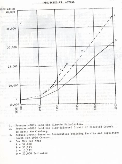
Davidson and Cornelius, two towns in North Mecklenburg, are presently growing in parallel rates, but have distinct views on the future of their respective developments. In 1960 Davidson held a population U.S. Census count of 2573 people while Cornelius had a count of 1,444. By 1988 Davidson held 3,000 and Cornelius 3,900.

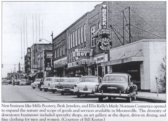
The introduction of Lake Norman provided an opportunity for both towns to develop into what was formerly dismissed by crowds who were discouraged by the lack of job opportunities in the area. In both towns employments was characterized by the textile industry or were service oriented. At Davidson, Davidson College as an institution also provided employment outlets. In 1963 when the Lake was completed construction in both of these towns boomed and a population growth pattern ensued. To accommodate for the incoming population not only was there an increase in the construction of housing units, but business and retail outlets as well.

Davidson has historically sided with remaining a small town, priding itself in its historical significance and preserved quaint character. To this day, it wants to remain a small town though that is coming in to question with the increasing populations.

Cornelius, though similar to Davidson, encourages the growth of its town. In fact it has become increasingly commercialized with far more outlets, restaurants, and hotels than Davidson. Resource demands have even driven Davidson residents into the neighboring town of Cornelius as it has become the commercial center for North Mecklenburg.

Needless to say each of these towns’ individual quaint identity is threatened by increasing populations and their resource demands. 

Mooresville

Mooresville

mooresville land development plan

Mooresville’s development plan made the area convenient, modern, and attractive.

In Mooresville, the “Mooresville Plan” was set forth as a means to develop the area with the modernization of buildings, the development of a pedestrian mall, and installation of canopies over sidewalks. The town promoted its amenities to visitors that frequented the lake, attracting more and more people to the area. It was marketed as “a charmingly social, vigorously industrial and soundly built community which is making steady progress and where living conditions are of the best kind.”  Mooresville with its proximity to the lake and amenities promoted themselves to new visitors that were on the way to the lake. The town’s supermarkets, restaurants, department stores, churches and service stations provided the comfort and convenience sought by those visiting the town or Lake Norman. Beyond that it also provided recreational outlets with an attractive golf course.

diversity of business mooresville

Population Growth Trends

1988-1990

Population Growth Trends

A graph demonstrating the projected population growth versus the actual growth based on residential building permits and population count for the 1990 Census data.

A graph demonstrating the projected population growth versus the actual growth based on residential building permits and population count for the 1990 Census data.

North Mecklenburg’s initial slow population growth was primarily due to the large families, and small farms that characterized its landscape. The farms were generally too small to be economically viable which drove plenty of families away from the farms and into the cities. The trajectory changed completely after the introduction of the lake, and for various reasons.

Though new housing developments near or on the lake were an impetus, I-77 North Mecklenburg also conveniently placed downtown Charlotte thirty minutes away from the Mecklenburg area.

Results were apparent within 3 years, by 1988. North Mecklenburg experienced one of the fastest growth rates in North Carolina with a growing rate of 17% from 1988 to 1989. From 1980 to 1990, approximately 4,454 units of residential permits were issued in North Mecklenburg and another 3,603 in Northeast Mecklenburg. Around 78% of this housing unit growth occurred only within a 5-year period.

Though people were generally happy

lakenormanwealth

with the growth and
development of the area, commonly used spaces and institutions such as roads, schools, police protection, garbage disposal faced pl

enty of readjustments du

e to population growth. Traffic congestion worsened and sewer lines have had to extend to more areas. Growth is also making it difficult for Cornelius, Davidson, and Huntersville to maintain the small town identities.

Development Plans

1976-1987

Development Plans

mecklenburg growth map

The heaviest concentration of growth occurred around Lake Norman in areas 428, with 1650 units, 429 with 1,211 units, and area 431 with 1,056 units.

After the lake was filled with water in 1963, population trends changed in the Lake Norman area. Slow development soon ensued such as zoning, county and municipal land use. On October 28, 1976 The Town of Davidson Zoning and Subdivision Ordinance was established, followed by Cornelius in 1977. Iredell County established preliminary zoning on land that drained into Lake Norman in order to ensure that the lake be kept pure and clean. As a result some land units in Iredell’s land bordering Lake Norman have yet to exercise their land use authority.

Land use development plans around Lake Norman were primarily formed to ensure that the water be kept pure. Plans, however, did not incorporate lakefront parks as opposed to housing units, an element that would have widened access to the use of the lake to a larger population. Mecklenburg County did, however, purchase land to establish two waterfront parks located west of NC Highway No. 73 southwest of Cornelius, N.C.

In 1985 there was an update to The 2005 Generalized Land Use Plan for Charlotte-Mecklenburg, a plan whose primary objective was to promote balanced growth in the area since it was noted that populations were concentrated in the eastern and southern part of the county. In 1984-85 a committee was formed to commission a land-use plan for Mecklenburg County where they divided seven planning areas. Eight categories of development took place after the lake’s introduction: Resort residential, urban residential, agricultural residential, access areas, commercial access areas, commercial, industrial and flood plains. The objective of this committee was to develop plans for the area and strategies for its growth through the year 2005. With this development plan in place, population growth results were apparent by 1988.

In 1985-1987 the Mecklenburg 20 Year County Land Use Plan was reviewed and modified to direct growth into northern Mecklenburg County via infrastructure and zoning. Towards the end of 1988 population curves increased so that the 1990 census count was 22,220 with 87.5% of its population being Caucasian. The heaviest concentrations of growth took place on the peripheries of Lake Norman, as can be seen in the map on the map above.

displacement

-1960s-1970s-

On Displacement:

lake norman dam

“Lake Norman provides a dependable supply of water to Lincoln, Davidson, Mooresville, Chalotte-Mecklenburg, and Huntersville, North Carolina. (Courtesy of Duke Energy).”

Prior to the building of Lake Norman, the Davidson area was predominantly characterized by agricultural farms. For twenty to thirty years the population remained stagnant until the construction of the lake. The lack of job opportunities and housing drove younger folks away from the area. However, the building of the lake changed the trajectory of population growth for North Mecklengburg. In the 1960’s population growth was mostly concentrated around the lake front properties with apartment and condominium projects booming.

Farmers were forced to move as the introduction of the lake took over their livelihoods. Families that held land for generations were forced to sell their land and move elsewhere. John Wally, a Lake Norman farmer felt like “he was like a displaced person in a foreign land.” Farmers were encouraged to sell their land in order to avoid “rumination of their crops and livestock” to be caused by the introduction of a future coal-burning plant expected to generate soot. However, Duke power decided against the coal burning plant, and when community leaders asked if they can re-buy their land it was being sold at $1000 per acre, a price farmers deemed “crazy” leaving them no option but to wait for prices to decrease.

-1980-1990s-

On Population Growth:

North Mecklenburg’s initial slow population growth was primarily due to the large families, and small farms that characterized its landscape. The farms were generally too small to be economically viable which drove plenty of families away from the farms and into the cities. After the introduction of the lake, families were further driven away from the area.

mecklenburg projectedvactual growth

Graph of the projected Mecklenburg population growth versus the actual growth based on 1990 census data.

North Mecklenburg, however,  experienced one of the fastest growth rates in North Carolina with a growing rate of 17% from 1988 to 1989. During a 10-year period, from 1980 to 1990, approximately 4,454 units of residential permits were issued in North Mecklenburg, 78% of which occurred within a 5-year period.

The introduction of Lake Norman was not the sole reason populations increased for the town of Davidson and Cornelius. Though new housing developments with waterfront views were an impetus, it was soon common knowledge that using I-77 North Mecklenburg conveniently placed downtown Charlotte thirty minutes away.

Development Plans

lakenormanwealth

In 1984-85 a committee was formed to commission a land-use plan for Mecklenburg County where they divided seven planning areas. Eight categories of development took place after the lake’s introduction: Resort residential, urban residential, agricultural residential, access areas, commercial access areas, commercial, industrial and flood plains. The objective of this committee was to develop plans for the area and strategies for its growth through the year 2005. With this development plan in place, population growth results were apparent by 1988.

mecklenburg growth map

The heaviest concentration of growth occurred around the development of the lake

In 1985-1987 the Mecklenburg 20 Year County Land Use Plan was reviewed and modified to direct growth into northern Mecklenburg County via infrastructure and zoning. Towards the end of 1988 population curves increased so that the 1990 census count was 22,220 with 87.5% of its population being Caucasian. The heaviest concrentrations of growth took place on the peripheries of Lake Norman, as can be seen in the map above.

Davidson and Cornelius

Davidson has historically sided with remaining a small town, priding itself in its historical significance and preserved quaint character. Cornelius, though similar to Davidson, encourages the growth of its town. Increasing populations have placed a  high demand for development of these towns, a change that may come at the cost of losing the town’s distinct identities.

Cornelius has become more commercialized than Davidson. Market conditions then drive Davidson residents into Cornelius, where the town is becoming increasingly commercialized. Each of these towns’ individual characteristics are threatened by increasing populations and their resource demands.

Lincoln County

Unlike the other side of the lake, Lincoln County did not experience the influx of wealth that accompanied Lake property. Newspapers indicate that Lincoln County was equally excited about the prospect of new development from the lake as the east side, yet the actual results of development were much different.

Mooresville

mooresville land development plan

Mooresville development plan made the area convenient, modern, and attractive.

In Mooresville, the “Mooresville Plan” was set forth as a means to develop the area with the modernization of buildings, the development of a pedestrian mall, and installation of canopies over sidewalks. The town promoted its amenities to visitors that frequented the lake, attracting more and more people to the area.

 mooresville amneties


Sources:

Brotherton, Ken. Lake Norman–Piedmont History. Davidson, N.C. (138 Meadowbrook Lane, P.O. Box 62 Davidson 28036): K. Brotherton, 1993. Print.

Jacobs, Cindy. Around Lake Norman. Charleston, SC: Arcadia Pub., 2008. Print.