The creation of Lake Norman has had significant impact on the demographics of the four counties surrounding the lake. In the following links we discuss demographic changes in Davidson, Cornelius, and Mooresville and document population growth trends, future development plans, and displacement .
Partnership with Myers Park Church
April 3, 2014 By Leave a Comment
In March of 1978, Business Manager Robert Currie began discussing a potential partnership with Myers Park Church. Church leadership indicated that they would be able to raise $75K-$100K for a pavilion, cook-out facilities, and a pier. The church’s use would be limited and mostly for sunday school and summer camps. The primary obstacle was adaquete staffing of the property.
In November of 1979, Currie continued discussing the Myers Park partnership with Athletic Director Thomas Cartmill and Rev. Dr. R. Taylor of Myers Park Church. The initial indication of a donation of a pavilion and other facilities was no longer feasible, but the two parties did agree to enter in to a partnership for a 2-year trial period. They agreed to split the cost of a full time ranger. Currie stated that, “Sterling feels this move will give to the Lake Campus a needed shot in the arm.”
In 1982, this partnership was renewed again for a third summer.
References
Currie, Robert A. Letter to Dr. Cartmill. 8 November 1979. RG 4/1.1. VP for Business and Finance. Lake Campus Development, 1973-1977. Davidson College Archives, Davidson, NC.
Currie, Robert A. Letter to President Spencer. 31 March 1978. RG 4/1.1. VP for Business and Finance. Lake Campus Development, 1973-1977. Davidson College Archives, Davidson, NC.
Trump National Golf Club
April 3, 2014 By Leave a Comment
Founded in 1999, The Point Golf Club was designed by Greg Norman (acclaimed former professional golfer, golf course designer, and entrepreneur) to serve the rapidly developing community. However, in 2011 the club’s tenor changed significantly when Trump International Realty (originally founded by the one and only Donald Trump) purchased the club. Renamed Trump National Golf Club, according to Trump the club now “provides more than a membership-it’s a true luxury lifestyle.” Undoubtedly the crown jewel of the The Point, recent trends suggest membership will continue to grow as homes are built and purchased throughout The Point.
Griffith Street: Major Town and College Projects
April 1, 2014 By Leave a Comment
Griffith St. Community Center: Shutdown and Repurposing
Perhaps one of the earliest attempts by the town of Davidson to refurbish the main thoroughfare of Griffith Street came in the early 1950s with the shutdown and repurposing of a YMCA-sponsored community center constructed on grounds owned by the ADA Jenkins school. After a review of the legal land use regulations associated with the plot of land, the use of the land as grounds for a YMCA facility was determined an illegal use, and the land was bought by Davidson College in 1954 for repurposing. After years of continued maintenance of the deteriorating building, the movement of the community center to the current location of the ADA Jenkins Center allowed Davidson College to take over rights to the building in 1974 (Community Center – Griffin Street, Letter from Robert Currie to Dean Burte). Finally, in 1977, President Spencer communicated his desires to demolish the building and completely repurpose the land (Griffin Street – Community Center Building, Memo from Robert Currie to President Spencer).
Griffith Street, Roosevelt Wilson Park, and the Algae Pond Committee
In the early years of the 1970s, Davidson’s Town Board expressed significant interest in repurposing the small extension of Lake Norman located on the south side of Griffith Street, a pond that had grown into a deteriorated state. While some proposed to simply fill in the pond, others became eager to remodel and redesign the pond and the empty land around it. In turn, Davidson’s Town Board formed a small party in charge of planning and executing the lake and the land’s remodeling. This newly formed Algae Pond Committee drafted and sent to Duke Energy—the legal maintainers of the pond—a series of propositions pertaining to the transformation of the land around the lake into a proper park. These propositions included significant re-landscaping, the construction of walking paths, the planting of more trees, and the addition of lighting to the park for nighttime use. Through this restructuring and repurposing of the area, it was believed that the continued build-up of algae and trash that had come to plague the pond might be reversed. (Lake Area on Griffin Street, Memo from Gover Meetze, Jr. to President Spencer)
In the 1990s, another two-phase project was organized after the complaints of several neighbors about the bad appearance of the entryway to the college from Griffith Street, mostly attributable to a worsening condition of the park and pond. The town of Davidson was given $77,000 from the North Carolina Parks and Recreation Trust Fund for the renovation of the park on the condition that the town matched it. Collected silt from the pond was removed to uncover its natural bottom, while spillways were added to promote drainage into pipes around the pond, the few jogging trails were cleaned up, and a large playground was constructed. An additional $50,000 was donated for the construction of a boardwalk across the pond and creation of a path that bypassed Griffith Street traffic. (Goodson, 1997)

Contemporary picture of Roosevelt Wilson Park
Courtesy of The Town of Davidson website
Another important factor in the reorganization of the park and pond during the 1990s was the voice of the Davidson homeowners living directly adjacent to the park. A largely African American group, sentiments were largely split around whether this renovation effort would be a positive development. Many of these residents were unable to afford memberships to the YMCA, the nearest recreational facility, and wanted a space for recreation. Others remained concerned that the renovation of the park was a first step in a process of gentrification, as renovations might raise property prices in the area, property prices which they might no longer be able to afford. (Schuetz, 1996)
This was but one of the many conflicts centered around race relations that took place during these developmental years for Griffith Street. For more information on the social implications of the development of Griffith Street, click here.
Griffith Street Properties, Inc.
In 1981, four Davidson College alumni–Howard W. Covington, Robert A. Currie, Lawrence M. Kimbrough, and John A. Tate, Jr.–founded a new non-profit organization named Griffith Street Properties, Inc. With the mission “to preserve, restore, renovate, upgrade, develop and take all necessary action to improve and promote revitalization of Griffith Street” (Eure, 1981), this organization, which included Davidson College’s Business Manager Robert A. Currie, worked to redirect certain funds contributed by Davidson alumni who specified that their donations go towards revitalization projects helmed by Griffith Street Properties, Inc. As Howard Covington, “the driving force behind the corporation,” explained his motivations, “’I just kept seeing these houses painted all kinds of wild colors and junk cars in the front and I didn’t think this was a good entryway to a beautiful college campus’” (Mellnik, 1984).
‘I just kept seeing these houses painted all kinds of wild colors and junk cars in the front and I didn’t think this was a good entryway to a beautiful college campus.’
A variety of major players participated in this renovation effort helmed by Griffith Street Properties through substantial donations and loans, including, most importantly perhaps, two different local banks: Northwestern Bank (contributing some $2,500) and Piedmont Bank and Trust (contributing $25,000 over five years). These funds were utilized directly in the purchasing of homes and land from a variety of homeowners–primarily lower income and African American homeowners–along Griffith Street. For the most part, homeowners who decided to sell their land were set up with newer, oftentimes nicer homes located nearby. As voice in John A Tate, Jr.’s letter to Howard Covington, interest existed to not only beautify these acquired plots, but to repurpose them for use by the college and the town: “Consideration should be given to making this land available for high technology, engineering, architecture, or other types of business compatible with academic affairs at the college” (Plans for Griffith Street, Letter from John A. Tate to Howard Covington). So although beautification was one primary goal of Griffith Street Properties, Inc., providing a range of functional facilities was a secondary one.
Davidson College’s direct involvement in the transplant of Griffith Street homeowners away from this major thoroughfare funneling traffic to the college was evidenced not only by Robert A. Currie’s hands-on role, but also in the direct role played by Davidson College’s President John W. Kuykendall. Appearing as a simple ‘cc.’ in a wide variety of letters between Griffith Street Properties, Inc. trustees and other role players (such as the banks mentioned above and other funders of the project) during the later part of 1984 and 1985, archival documents also reveal his attendance of a number of Board of Trustees meetings during these later years of the organization’s lifespan. The work of Griffith Street Properties, Inc. was not simply the lovechild of a few select alumni from the college; Davidson College fully monitored, partly funded, and deftly supported this beautification endeavor.
For more information on the economic development of Griffith Street, click here.
Sources:
Robert A. Currie. Letter to Dr. Samuel Reid Spencer. March 9, 1977. Davidson College Archives. Davidson, NC.
Robert A. Currie. Letter to Dean Burte. October 22, 1968. Davidson College Archives. Davidson, NC.
Eure, Thad. “Articles of Incorporation of Griffith Street Properties, Inc.” Articles of Incorporation. Notarized Document. 5 November, 1981. Davidson College Archives. Davidson, NC.
Goodson, Jessica. “Griffith gets a make over.” Davidsonian. 2 September, 1997.
Grover C. Meetze, Jr. Letter to Dr. Samuel Reid Spencer. April 29, 1970. Davidson College Archives. Davidson, NC.
Mellnik, Ted. “Davidson’s urban renewal a private affair.” The Charlotte News. 26 March, 1984. Davidson College Archives. Davidson, NC.
Schuetz, Jennifer. “An Integrated Approach to Analyzing Options for the Davidson Pond.” 1996. Davidson College Archives. Davidson, NC.
John A. Tate. Letter to Howard Covington. 13 November, 1984. Davidson College Archives. Davidson, NC.
Roosevelt Wilson Park. Photograph. n.d. “The Town of Davidson’s Public Art Commission Seeks Artist for Artwork: Installation at Roosevelt Wilson Park To Honor Pat Knox.” The Town of Davidson. Web. 9 April, 2014.
Sterling Martin Development Plan
April 1, 2014 By Leave a Comment
Development of the campus gains more traction when Sterling Martin rolls out a very extensive development plan for both the lake campus and the equestrian program. Click Martin Development Plan to view the entire plan.
References
Martin, Sterling. New Davidson College Lake Campus Summer Policy. 25 May 1979. RG 2/1.16. Athletics-Lake Campus, 1973-1987. Davidson College Archives, Davidson, NC.
The Flood of 1916: Bridges
March 31, 2014 By Leave a Comment

Building a temporary replacement structure near Fort Mill, SC. From: Southern Railway, 1917.
More than several dozen bridges were taken out by the rushing waters of the flood of 1916. These bridges, suspended over the Catawba River, were washed away by the rising waters and resulted in several of the deaths and several of the hundreds of thousand dollars in damage that the flood resulted in. The Belmont Bridge trapped 18. The Seaboard Air Line steel bridge at Mount Holly, the Interurban steel bridge, and the county highway steel bridge were all brand new and were estimated to have been worth over $125,000 at that time. Perhaps one of the most memorable bridge collapses though was the Southern Railway’s bridge that was only 11 miles from Charlotte and largely affected the transportation and communication in and out of the city after the flood.
displacement
February 27, 2014 By Leave a Comment
-1960s-1970s-
On Displacement:

“Lake Norman provides a dependable supply of water to Lincoln, Davidson, Mooresville, Chalotte-Mecklenburg, and Huntersville, North Carolina. (Courtesy of Duke Energy).”
Prior to the building of Lake Norman, the Davidson area was predominantly characterized by agricultural farms. For twenty to thirty years the population remained stagnant until the construction of the lake. The lack of job opportunities and housing drove younger folks away from the area. However, the building of the lake changed the trajectory of population growth for North Mecklengburg. In the 1960’s population growth was mostly concentrated around the lake front properties with apartment and condominium projects booming.
Farmers were forced to move as the introduction of the lake took over their livelihoods. Families that held land for generations were forced to sell their land and move elsewhere. John Wally, a Lake Norman farmer felt like “he was like a displaced person in a foreign land.” Farmers were encouraged to sell their land in order to avoid “rumination of their crops and livestock” to be caused by the introduction of a future coal-burning plant expected to generate soot. However, Duke power decided against the coal burning plant, and when community leaders asked if they can re-buy their land it was being sold at $1000 per acre, a price farmers deemed “crazy” leaving them no option but to wait for prices to decrease.
-1980-1990s-
On Population Growth:
North Mecklenburg’s initial slow population growth was primarily due to the large families, and small farms that characterized its landscape. The farms were generally too small to be economically viable which drove plenty of families away from the farms and into the cities. After the introduction of the lake, families were further driven away from the area.
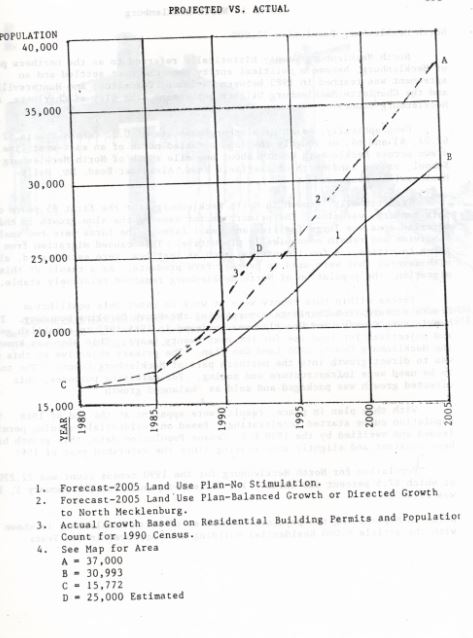
Graph of the projected Mecklenburg population growth versus the actual growth based on 1990 census data.
North Mecklenburg, however, experienced one of the fastest growth rates in North Carolina with a growing rate of 17% from 1988 to 1989. During a 10-year period, from 1980 to 1990, approximately 4,454 units of residential permits were issued in North Mecklenburg, 78% of which occurred within a 5-year period.
The introduction of Lake Norman was not the sole reason populations increased for the town of Davidson and Cornelius. Though new housing developments with waterfront views were an impetus, it was soon common knowledge that using I-77 North Mecklenburg conveniently placed downtown Charlotte thirty minutes away.
Development Plans
In 1984-85 a committee was formed to commission a land-use plan for Mecklenburg County where they divided seven planning areas. Eight categories of development took place after the lake’s introduction: Resort residential, urban residential, agricultural residential, access areas, commercial access areas, commercial, industrial and flood plains. The objective of this committee was to develop plans for the area and strategies for its growth through the year 2005. With this development plan in place, population growth results were apparent by 1988.
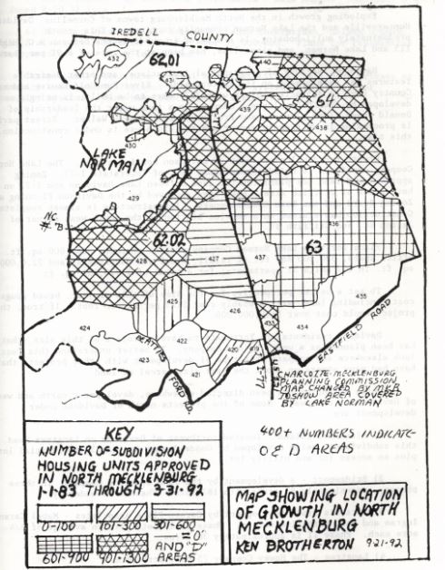
The heaviest concentration of growth occurred around the development of the lake
In 1985-1987 the Mecklenburg 20 Year County Land Use Plan was reviewed and modified to direct growth into northern Mecklenburg County via infrastructure and zoning. Towards the end of 1988 population curves increased so that the 1990 census count was 22,220 with 87.5% of its population being Caucasian. The heaviest concrentrations of growth took place on the peripheries of Lake Norman, as can be seen in the map above.
Davidson and Cornelius
Davidson has historically sided with remaining a small town, priding itself in its historical significance and preserved quaint character. Cornelius, though similar to Davidson, encourages the growth of its town. Increasing populations have placed a high demand for development of these towns, a change that may come at the cost of losing the town’s distinct identities.
Cornelius has become more commercialized than Davidson. Market conditions then drive Davidson residents into Cornelius, where the town is becoming increasingly commercialized. Each of these towns’ individual characteristics are threatened by increasing populations and their resource demands.
Lincoln County
Unlike the other side of the lake, Lincoln County did not experience the influx of wealth that accompanied Lake property. Newspapers indicate that Lincoln County was equally excited about the prospect of new development from the lake as the east side, yet the actual results of development were much different.
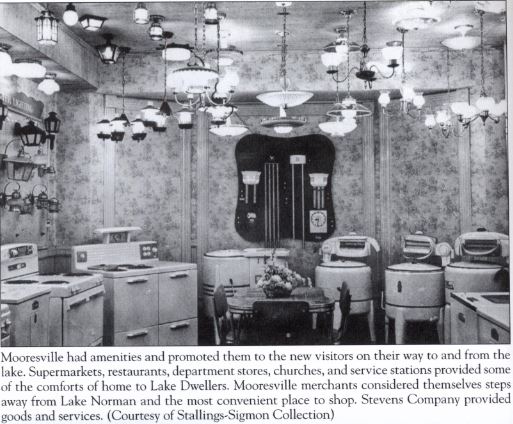
Mooresville
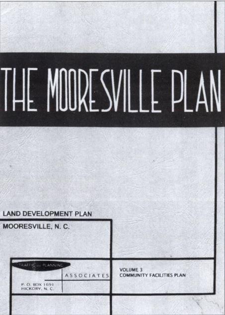
Mooresville development plan made the area convenient, modern, and attractive.
In Mooresville, the “Mooresville Plan” was set forth as a means to develop the area with the modernization of buildings, the development of a pedestrian mall, and installation of canopies over sidewalks. The town promoted its amenities to visitors that frequented the lake, attracting more and more people to the area.
Brotherton, Ken. Lake Norman–Piedmont History. Davidson, N.C. (138 Meadowbrook Lane, P.O. Box 62 Davidson 28036): K. Brotherton, 1993. Print.
Jacobs, Cindy. Around Lake Norman. Charleston, SC: Arcadia Pub., 2008. Print.