Guest Blogger: Paul Mullinax C’22, Environmental Studies Major “The African American Burial Grounds Network Act”

Originally from Athens, GA, Paul Mullinax ‘22 is an Environmental Studies major and Anthropology minor. He is also a member of Davidson’s Varsity Men’s Track and Field team and in his free time is an avid hiker who spends time outdoors.

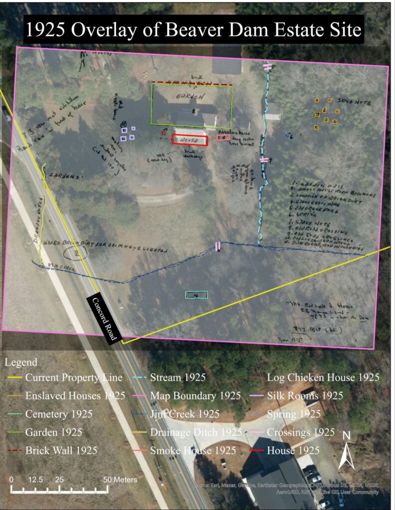
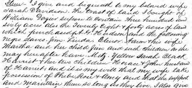
Over the last couple years, Davidson College has begun addressing the problematic aspects of its history, particularly its connection to the Davidson family, their plantation, and their ownership of slaves. What’s left of the plantation, referred to as the Beaver Dam Estate, is just a short five-minute drive from Davidson’s campus. During the 2021 spring semester our class, Ethical Archaeological Research, set out to research this plot of land in hopes of uncovering and preserving a story that had yet to be told. In particular, we believe there is strong evidence of a cemetery used by the enslaved people of Beaver Dam, an important discovery that should be preserved. For this reason, it is imperative that we understand the current state, county, and federal laws surrounding historic black cemeteries and what this could mean for Beaver Dam.

Color photo of a clearing in the woods near Beaver Dam Plantation; possible location of a cemetery for enslaved people.
A view of the Beaver Dam Plantation house from the hypothesized location of the historical cemetery used by the enslaved (photo by Dr. Maxime Lamoureux-St-Hilaire).

 As of the writing of this blog post, there is currently no federal law protecting historic African American cemeteries. These cemeteries are often at risk of being destroyed due to development, but a new bill could change that. Just recently the African American Burial Grounds Network Act was unanimously passed by the Senate and is now waiting to be voted on by the House. This bill could implement a network to help coordinate experts and community leaders to help with the preservation of historically significant cemeteries such as the one at Beaver Dam.

Originally proposed in the House in 2019 by Alma Adams, Rep for North Carolina’s 12th District which includes Davidson, the bill initially failed to make headway. This was for a few reasons. For one, the cost of such a program seemed difficult to justify given what other projects already existed. There already exists a National Underground Railroad Network to Free as well as the African American Civil Right Networks. On top of that The Reconstruction Era National Historic Network and a network focusing on the interpretation and commemoration of the Transcontinental Railroad were already in the works to be set up. These concerns were brought to life by the Deputy Director of the DOI and NPs during a subcommittee meeting in May of 2019. They stated that for the reasons of costs and preexisting and similar projects, they would not support the bill, nor the creation of this network. Luckily the Bill was revived, this time in the Senate, by Senator Sherrod Brown of Ohio and is progressing much better than its predecessor.

The proposed network would work similarly to the already existing networks previously mentioned, working through the NPS and providing funding for technical support, recording, documentation, and other forms of aid to any project that requests help. This is exactly the kind of help that the Beaver Dam project could benefit from, and with a little luck, it may not be long before we have the resources necessary to proceed with the next steps of this project.

Complementary information may be found here:

https://www.smithsonianmag.com/smart-news/legislation-protect-african-american-burial-grounds-passes-senate-180976642/

https://afro.com/senate-passes-bill-to-create-african-american-burial-grounds-network/

https://www.brown.senate.gov/newsroom/press/release/brown-bill-national-network-african-american-burial-grounds

Guest Blogger: Sara Wilson C’22 Anthropology Major “Mapping the Landscape of Beaver Dam”

Sara Wilson (she/her) is a senior Anthropology major from outside San Francisco, California. She is interested in osteology, archaeology, and ethical research methods in anthropology.

Maps and spatial data increase understanding of the Beaver Dam site during both historical and contemporary times, which lays the groundwork for potential future archaeological investigation. The goal of these maps is to help identify where the houses and cemetery for the enslaved people at Beaver Dam (documented on historical documents) were located. Satellite imagery, LiDAR data, and historical maps were combined in the ArcGIS Pro software to highlight the topography and possible locations of the cemetery and houses. While in-person site survey is integral and yields meaningful discoveries, creating maps is worthwhile as they can reveal patterns, nuances, and spatial relationships that may not be immediately obvious.

As shown by satellite imagery of Beaver Dam, the property is now far smaller than when it was a working plantation, which underscores the possibility that significant features may have been destroyed by neighboring housing developments.

Satellite map of the Beaver Dam site

Two historical maps of the Beaver Dam plantation site are sketches from 1865 and 1925. Despite being imprecise, these maps indicate important information that is absent from most historical accounts of Beaver Dam. Both maps included an area for enslaved people’s houses and a cemetery for enslaved people. While the scale of these historical maps is off, analyzing them in conjunction with current satellite imagery and LiDAR data, allowed us to narrow down the potential locations of the houses and cemetery. Topographic raster analyses based on LiDAR data, including hillshade, slope, and elevation contour, reveal a steep incline down to a creek bed along the eastern side of the property. The historical maps position the enslaved houses relative to the main house and to the creek, so having the actual locations of both helps deduce where the remains of the houses may be located. Analyses of the maps indicate that if there ever were houses between the Beaver Dam house and the creek as indicated by the 1865 map, it is likely they are located between the current tree line and west side of the creek.

Elevation contour lines over hillshade analysis of the Beaver Dam site

However, if there was a cluster of houses past the creek as shown in the 1925 map, the River Run housing development was unfortunately likely built on top of it, given the creek marks the eastern boundary of the property. The historical maps indicate that the cemetery was located south-southeast of the main house. This is also supported by topographic data, given that cemeteries are typically located on higher ground. If this project moves forward, the cemetery area should be marked and preserved, and the location of houses could be investigated through archaeological investigations.

1865 map georeferenced over satellite imagery of Beaver Dam site.
1925 map georeferenced over satellite imagery of Beaver Dam site.
Concluding location estimations of houses and cemetery for enslaved people at Beaver Dam.

This mapping project will have continued utility if the Beaver Dam project proceeds, as geolocating features, artifacts, and other archaeological findings would be a useful visualization technique. These maps are also helpful for working with the community, as they are a way to communicate information that is visually interesting and more accessible.

Guest Blogger: Isabel Nowak Anthropology Major C’23, “The History of Beaver Dam”

Isabel Nowak is a junior anthropology student at Davidson College. In spring 2021, they spearheaded archival research in Dr. Maxime Lamoureux-St-Hilaire’s Ethical Archaeology seminar which investigated the silenced history of Beaver Dam Historical Park.

Hello! My name is Isabel Nowak, and Spring semester 2021, I was enrolled in a seminar with Dr. Maxime Lamoureux-St-Hilaire where my peers and I investigated the local Beaver Dam historical park. Beaver Dam’s history isn’t super well-publicized, so I thought I’d share some of it here.

 The first major player in our story is William Lee Davidson, not to be confused with his father General William Lee Davidson, who died in the Battle of Cowan’s Ford a month after his son’s birth in 1781. In 1808, Davidson purchased 451 acres on Beaver Dam Creek (hence the name of the property), where he established a plantation. The actual house that still stands today was not completed until 1829.

 Sometime between October 1847 and December 1848, William Lee Davidson moved to Alabama, and in preparation, he sold his tract on Beaver Dam Creek to Joseph Patterson, who moved in with his wife and son. Patterson died suddenly in 1858, and his son John subsequently inherited the property. The Pattersons were gone by 1880, and following decades were full of exchanges (usually to settle debt), and over time, the property was divided up.

In 1937, then-owner Caldwell Hovis sold 8.5 acres consisting of the plantation house and immediate area to Dr. Chalmers G. Davidson, who restored the house from 1945 to 1975, when he moved in. The house was listed as a Charlotte-Mecklenburg Historic Site in 1977 and placed on the National Register of Historic Places in 1979.

Davidson College purchased the house and 8 acres of the adjoining lands in 1998 due to the land’s significance to the college’s past. Indeed, in 1935 a committee of the Concord Presbytery met at the plantation house and decided on the location of what came to be Davidson College, named after William Lee Davidson’s father, General William Lee Davidson. However, not many sources mention Beaver Dam’s darker history.

Excerpt of the Will of William Lee Davidson including a list of enslaved people.
List of enslaved people held by Joseph Patterson

Jim, Linda, Aaron, Martha, Jim, Sarah, Harriet, Horace, John, Phebe, Rose, and Amy. Jane, Darky, Tilly, Lee, Taylor, Frances, Dallas, and Mary. These are the enslaved peoples referred to by name in the will/probate records of William Lee Davidson and Joseph Patterson respectively. According to census records corresponding to years he occupied Beaver Dam, William Lee Davidson owned 15 slaves in 1820, 21 in 1830, and 26 in 1840. Joseph Patterson owned 25 slaves by 1850. We don’t know a lot about the enslaved people that lived and worked on the Beaver Dam plantation. There are no written records of most of them. But, hopefully, this investigation into Beaver Dam will raise awareness of its history, and the people who lived and died there.

Guest Blogger: Mandy Muise Anthropology Major C’23,”Community-Based Public Research in Archaeology: An Outsider’s Perspective”

Mandy Muise is a sophomore currently majoring in anthropology with an intended minor in Latin American studies. On campus, they work as the anthropology consultant for the Writing Center and are currently interning with the Antiquities Coalition.

As part of the Ethical Archaeological Research seminar, I began my work on a project called Historical and Community Archaeology: The Enslaved People of Beaver Dam (henceforth referred to as the Beaver Dam project) as a bit of an archaeological outsider – and to a degree, I remain one. Although I am an anthropology major, my concentration has always been on the cultural side; as a result, I found myself outside of my comfort zone in an archaeology seminar. It took me quite some time to find my place in a project defined by archaeological perspectives and jargon I had not previously encountered. I found myself lost as to what we could gain from pottery sherds and confused about what possible implications historical archaeology could have upon a community. Archaeology is built upon colonial ways of knowing, and prior to becoming introduced to Community Based Participatory Research in archaeology (CBPR, discussed below), I saw zero potential for an archaeology that actively served a community.

color photo of front of Beaver Dam plantation house
Beaver Dam Plantation House

In most simplistic terms, CBPR is an archaeology that advocates a movement away from scholarship “on and for” and toward archaeological practice “by and with” a community. It was best defined by Sonya Atalay (2012), an archaeologist specializing in Indigenous archaeology. CBPR creates a methodology that seeks to decolonize archaeological practice to create a more equitable form of research that is mutually beneficial to the community and to academics alike through the democratization of the knowledge production process.

My role in this project ultimately consisted of contacting prominent members of the community for information, advice, and to build connections for eventual in-person activities. In doing this, I’ve developed an appreciation of the difficulty of engaging in CBPR with a community that has not expressed an interest in archaeology. As a result of these challenges, our project has not consistently been able to uphold the objectives and ideals of CBPR. As it stands, our project is not community-engaged beyond the intentions of our group, as our accomplishments thus far have been without the support or desire of the community.

How can we understand this project to be an anti-racist and ethical endeavor in lieu of community engagement? Rather than seeing the project as aligning with older archaeological practices, it is critical to recognize our project at Beaver Dam as still in its initial stages. We have hardly stepped back from the chalkboard, despite the semester coming to a close. What we have successfully done is set the stage for CBPR, creating space in which this project can come to fruition. Our project has been designed with endless flexibility in hopes of community engagement – research questions and ideas are open to adjustments, and excavation can and will wait for the community. I see the Beaver Dam project as full of potential, founded upon ethical and anti-racist intentions – assuming the project continues its trajectory of community engagement, I have confidence that this project will continue to emphasize service to the community through mutually-beneficial scholarship.

Bibliography

Atalay, Sonya

2012    Community-Based Archaeology: Research with, by, and for Indigenous and Local Communities. University of California Press, Berkeley.

Guest Blogger: Dr. Maxime Lamoureux-St-Hilaire Visiting Assistant Professor, Anthropology “Historical Archaeology and the Enslaved of Beaver Dam”

This is the first of five posts from Dr. Maxime Lamoureux-St-Hilaire’s Ethical Archaeological Research seminar (ANT-380) summarizing the results of their preliminary work on the Beaver Dam Plantation in Davidson, North Carolina.

The role of archaeology is to study societies of the past by examining their material record and the landscapes they inhabited. Historical archaeology juxtaposes the written record to these evidences to gain an even richer understanding of past societies. This written record may come from archives or can literally be found on the artifacts found during excavations. In this, historical archaeology has two incredible advantages as a social science: (1) it offers a rich type of evidence that is unavailable to non-historical archaeology and (2) offers a vast amount of material culture while paying attention to landscapes in ways that are typically evacuated from strict historical lenses. Historical archaeology can thus fill-in the many blind spots of the historical record, which tends to be written by the powerful or literary elite of the past; in this, historical archaeology can be framed as “anti-history” (Lee-Dawdy 2016). In other words, this anti-historical power can shine a light on past realities which were either erased or muted by history; those of past people suffering from intersectional inequities.

For decades, historical archaeologists have documented the lives of people whose stories were muted. This approach has had great success in studying the socioeconomic context, personal practices, challenges, and violence which characterized the lives of the people who were enslaved by plantation owners in the USA and beyond. More recently, historical archaeologists have also studied the realities of the post-emancipation life of African American households (Franklin et al. 2020). This broad research field is known as African Diaspora Archaeology and is spearheaded by members of the Society of Black Archaeologists, who are actively encouraging accomplices to contribute in steering the discipline towards an antiracist future (Flewellen et al. 2021).


A view of the Beaver Dam Plantation house from the hypothesized location of the historical cemetery used by the enslaved (photo by the author).

In this series of blog posts, my four students – Mandy Muise, Paul Mullinax, Isabel Nowak, and Sara Wilson – from the Ethical Archaeological Research seminar (ANT-380) and I summarize the results of our preliminary work on the Beaver Dam Plantation. This past semester, we studied the archival record, the landscape, and the potential for a community-engaged archaeology project at the site. The remaining estate is a small park – located at 19600 Davidson-Concord Rd – owned by Davidson College and currently leased to the Town of Davidson. Our work has identified important features of this landmark which have been effectively muted from its history and contemporary landscape: namely, the probable locations for the homes and cemetery of the enslaved who lived and labored on these grounds in the 19th century. This project has antiracist roots and goals: it aims to redress history through a historical archaeological program to give back the voices to those who’ve been muted by history.

The design of this project was influenced by experienced historical and community-engaged archaeologists and by the rich and recent literature on the Archaeology of African Diaspora and Community Engaged Archaeology (Agbe-Davies 2017; Atalay 2012; Battle-Baptiste 2017; Colwell 2016; Dunnavant 2014; Engmann 2019; Flewellen 2017; Flewellen et al. 2021; Franklin 2019; Franklin et al. 2020; Fryer 2020; Joseph 2016; Kawelu 2014; McAnany 2020; McDavid 2007; Odewale 2019; Ogundiran and Falola 2007; Reeves 2004; Shackel 2013; White 2016, 2017).

We, the five members of this project, are white. We’ve strived to use our various privileges to position ourselves so that we may launch a small, ethically-grounded project seeking to collaborate with the local Davidson community to identify and achieve antiracist goals. In fact, any future research as part of our project will be developed in collaboration with members of the Davidson Community. The powerful lenses of historical archaeology and our preliminary findings give us confidence that this project could transform Beaver Dam into a place of positive historical awareness that would benefit the broader community.

Funding for this project was provided by Davidson College’s Stories (Yet) to be Told program.

Bibliography

Agbe-Davies, Anna

2017    Where Tradition and Pragmatism Meet: African Diaspora Archaeology at the Crossroads. Historical Archaeology 51:9-27.

Atalay, Sonya

2012    Community-Based Archaeology: Research with, by, and for Indigenous and Local Communities. University of California Press, Berkeley.

Battle-Baptiste, Whitney

2017    Cruise Ships, Community, and Collective Memory at Millars Plantation, Eleuthera, Bahamas. Historical Archaeology 51(1):60–70.

Colwell, Chip

2016    Collaborative Archaeologies and Descendant Communities. Annual Review of Anthropology 45:113–27.

Dunnavant, Justin

2014    Rehistoricizing African Archaeology through the Archives: The Intellectual Life of William Leo Hansberry. Archaeological Review from Cambridge 29(2):34-49.

Engmann, Rachael A. A.

2019    “Archaeo, That Useless Subject”: Excavating the Past through Autoarchaeology and Community Outreach Education. Ghana Studies 22:173-190

Flewellen, Ayana Omilade

2017    Locating Marginalized Historical Narratives at Kingsley Plantation. Historical Archaeology 51(1):71–87.

Flewellen, Ayana Omilade, Justin P. Dunnavant, Alicia Odewale, Alexandra Jones,

Tsione Wolde-Michael, Zoë Crossland, and Maria Franklin

2021    “The Future of Archaeology Is Antiracist”: Archaeology in the Time of Black

Lives Matter. American Antiquity 1-20 .Online Article.

Franklin, Maria

2019   Enslaved Household Variability and Plantation Life and Labor in Colonial Virginia. International Journal of Historical Archaeology 24:115-155.

Franklin, Maria, Justin P. Dunnavant, Ayana Omilade Flewellen, and Alicia Odewale

2020    The Future is Now: Archaeology and the Eradication of Anti-Blackness. International Journal of Historical Archaeology 24(4):753–766.

Fryer, Tiffany C.

2020    Reflecting on Positionality: Archaeological Heritage Praxis in Quintana Roo, Mexico. Archaeological Papers of the American Anthropological Association 31(1):26–40.

Joseph, J. W.

2016    Marks from the Past, Signs of the Future—the Dikenga of Historical Archaeology. Historical Archaeology 50(3):5–23.

Kawelu, Kathleen

2014    In Their Own Voices: Contemporary Native Hawaiian and Archaeological Narratives about Hawaiian Archaeology. The Contemporary Pacific 26(1):31–62.

Lee Dawdy, Shannon

2015    Anti-History. In Social Theory in Archaeology and Ancient History: The Present and Future of Counternarratives, edited by Geoff Emberling, pp. 328-342. Cambridge University Press, Cambridge.

McAnany, Patricia

2020   Imagining a Maya Archaeology That Is Anthropological and Attuned to Indigenous   Cultural Heritage. Heritage 3:1-11.

McDavid, Carol

2007   Beyond Strategy and Good Intentions: Archaeology, Race, and White Privilege. In An  

Archaeology of Civic Engagement and Social Justice, edited by Barbara Little and PaulShackel, pp. 67-88. AltaMira Press, Lanham.

Odewale, Alicia

2019    An Archaeology of Struggle: Material Remnants of a Double Consciousness in the

American South and Danish Caribbean Communities. Transforming Anthropology 27(2):114–132.

Ogundiran, Akinwumi, and Toyin Falola

2007    Pathways in the archaeology of transatlantic Africa. In Archaeology of Atlantic Africa and the African diaspora, edited by Ogundiran Akinwumi and Toyin Falola, pp. 3-45. Indiana University Press, Bloomington.

Reeves, Matthew B.

2004    Asking the Right Questions: Archaeologists and Descendant Communities. In Places in

Mind: Public Archaeology as Applied Anthropology, edited by Paul A. Shackel and Erve J. Chambers, pp. 71–81. Routledge, London.

Shackel, Paul

2013    Working with the Difficult Past: Examples from the University of Maryland. Annals of Anthropological Practice 37(1):57-71

White, William A. III

2016   Creating Space for a Place: The River Street Archaeology Project. Arizona Anthropologist 27:69-82.

2017    Writ on the Landscape: Racialization, Whiteness, and River Street. Historical Archaeology 51(1):131–148.

Guest Blogger: Anna Avinger, Davidson Senior Biology Major, “Growing Community”

Anna Avinger is a senior biology major on the pre-medicine track. This article stems from her independent study on community gardens. Fellow senior Ethan Landen and Anna became interested in this topic after their semester abroad in Australia, where they studied sustainable agriculture and ecology.

As the global pandemic rages on, community gardens in Charlotte continue to thrive. Here is a list of three community gardens that each have a different strategy for success. While they all have their own objectives and strategies, they share similar ideas: provide more access to food, increase sustainable efforts, and build community. 

Wilmore Garden

Wilmore Garden

The earliest community garden in Charlotte – Wilmore Garden – is one of many gardens within the organization, Charlotte Green. This organization has started several small gardens in urban neighborhoods all over Charlotte. Within each of them, community members can claim a small plot of land to plant and harvest their own crops. The gardeners learn from each other and grow in relationship with each other as they work. Board member, Cissy Shull, says that people are always at the Wilmore Garden working. When I went to Wilmore Garden, it was raining, but there were still people there, cleaning up the communal shed and organizing tools. The gardens provide people with something to do, something to be proud of, and something that brings the community together.

Davidson Community Garden

Davidson Community Garden

Davidson Community Garden was founded in 2010 by Eddie and Connie Beach as a part of the Davidson United Methodist Church. This garden is communally managed and harvested. Volunteers from all over Davidson come together on Saturday mornings to help out. Most crops are delivered to the food pantry at Ada Jenkins, a local non-profit. Eddie Beach emphasizes the impact of the garden on Davidson’s strong sense of community. “A story that I really like is that there was a grandmother who had the responsibility of getting her grandson to Davidson Elementary School, and he didn’t want to go. But he did like the scarecrows in the community garden, so she would get him out of the house by saying, ‘we’re going to the community garden to see the scarecrows.’ So, he’d get over here and look and be happy, and it was just a way to get him to go to school,” Beach said. “That is the kind of thing that really adds another dimension to the garden.”

Smithville Community Garden

Smithville Community Garden

Built on her grandparents’ land, Smithville Community Garden holds a special place in Natalie Mayhew’s heart. She explains that the garden was founded to bring people into the community. The founders wanted people to know about Smithville. Mayhew described the history of Smithville: Her great great grandmother worked for the Smith family picking cotton as a slave, and the family gave her and many other black slaves land to call their own. That’s how the community was born. Recently, as one of the remaining historically black communities, Smithville has been trying to fight gentrification efforts. In doing this, the Smithville Community Coalition, which runs the garden, works to emphasize the sense of pride and historical influence of the community. The garden has been a success. It gives people a place to come together and learn about Smithville, and it provides a wonderful place for rest and relaxation.

Through my research, I learned that the overwhelming emphasis of these gardens is to build community, which means different things for different gardens – whether its individuals working side-by-side on their own plots, families coming together for a common service project, or bringing in people from outside the community to raise awareness. There’s always more to it than planting seeds and harvesting produce.

Guest Blogger: Carlina Green, “Not Included in the Photograph”: Staff Underrepresentation in the Archives and How We Must Combat It (Part Two)

This is the second part of a two-part post by Carlina Green ‘20.

You see, the Archives cannot preserve sources that are never created. And when sources are not preserved in the Archives, their subjects can be underrepresented in narratives that draw on those sources or left out of such narratives entirely.

The staff of the Archives are committed to combating these historical silences, and they work to uncover and preserve the stories of populations underrepresented in the collections they administer.[1] This includes the stories of Davidson employees. Two examples of their exemplary work profiling 19th– and 20th-century staff include Niara Webb’s blog post on “Dean of Janitors” Mr. Enoch Donaldson and Hannah Foltz’s post on Davidson’s security officer “Cop” Ed Linker. Drawing on both archival materials and public records, Webb and Foltz try to piece together portraits of these historical actors about whom little has been preserved.

A photo of Enoch Donaldson standing in front of a building.
Photograph of Mr. Enoch Donaldson.

However, as Cottle mentioned, the content of posts dedicated to these past staff is limited to their work experiences, as that is the main focus of preserved, available sources. Furthermore, the Archives face a paucity of sources about the lives of current Davidson employees.[2]

One solution? Creating more of these sources by collaborating with staff who want to share their stories.[3] Students, consider interviewing interested college staff for your theses, capstone projects, or summer research. Faculty, please integrate staff history projects into your courses and into your own research. And compensate staff for their interview time; take advantage of research grants available for faculty, for students, and for faculty-student collaborations.

A portion of the College’s Statement of Purpose reads, “Davidson holds a priceless heritage bequeathed by those who have dedicated their lives and their possessions for its welfare.”[4] Part of honoring staff, who dedicate so much to this campus and its students, is valuing their life stories and memories. [5] They who offer so much to the College must be preserved in its history. So, let’s fight the silences; let’s create the sources that preserve their words and their legacies.


[1] One place this commitment is visible is in their documentary Always Part of the Fabric.

[2] Two examples of sources about current staff they receive consistently are speeches delivered on Employee Appreciation Day and winner lists for annual grants and awards like the Spirit of Davidson.

[3] For those concerned about protecting staff identities, remember that interviews donated to the archives can remain closed for a period of time (such as 50 years), or they can be anonymous.

[4] Some were forced to dedicate their lives to Davidson’s welfare, such as Susan, a young girl enslaved by former College President Rev. Drury Lacy.

[5] Today, many may choose to work at Davidson, but have little choice but to work long hours at salaries a few dollars above minimum wage to support their families.

Guest bloggers: Elise Edman and Dan Murphy, “How Mapping Davidson’s Campus Altered Students’ Perceptions of Campus”

Elise Edman is a senior Computer Science major, Data Science minor, and has just finished her last volleyball season at Davidson. Next year, she will be working in St. Louis, MO as a Systems Engineer for the Cardinals.

Dan Murphy is a junior Economics major, Data Science minor, and Data CATs consultant in the Hurt Hub. This summer, he will be working in Denver, Colorado designing, developing, and testing algorithms for darknet data at DarkOwl Cybersecurity.

In October of 2019, the students of Dr. Maxime Lamoureux-St-Hilaire’s course, Imaging the Earth (ANT 377), collectively mapped Davidson College’s campus. Using the “Collector for ArcGIS” app (available for download in Apple’s App Store), students walked around campus to collect the coordinates and other attributes of features like trash, garbage bins, trees, benches, art, honored objects (objects left alone and not stolen), and events. With this collaborative dataset, students were then tasked with using ArcGIS Pro software to create maps of Davidson’s campus with these features. This project ultimately changed the way that some students view the campus’ features and layout.

            One map that students created displays garbage bins with rings located 10, 20, and 40 meters away from the garbage bins’ coordinates (Map 1). The rings function to demonstrate the garbage bins’ proximity to each other and to trash found throughout campus. The map also features a representation of trash density on campus, where the darkest color is the area where trash is the densest. Most of the garbage bins and trash are found in the most student-frequented areas of campus, which is logical. It is interesting that the area with the densest trash is an area with plenty of garbage bins available to use. It appears that the distribution of garbage bins throughout campus is designed appropriately, but that students are not using them responsibly.

color map of the Davidson campus showing the location of garbage bins and loose trash

Map 1. Displays the distribution of garbage bins (with multiple ring buffers) and trash (with kernel density) throughout Davidson College’s campus.

            Another map that students created displays the benches around Davidson’s campus with rings located 15, 30, and 45 meters away from the benches’ coordinates (Map 2). In this context, the rings demonstrate the proximity of benches to other benches and artwork around campus. Students also used kernel density to analyze the density of benches and artwork throughout campus. As seen in Map 2’s legend, the red coloring represents the densest area of benches and artwork. The blue shading represents less densely-populated areas. The densest areas for benches and artwork on campus are near Chambers, Union, and the library. This is logical, as prospective students spend most of their time touring campus around these three spots. To make the campus visually attractive to visitors, it is logical that artwork and benches would be clustered in areas where they will be seen the most. Furthermore, there are additional dense areas behind the football field and near Baker Sports Complex. It appears that Davidson would do this to draw visitors to well-known on-campus locations.

color topographic map of the art and benches on the Davidson campus
Map 2. Displays the kernel density of art and benches and the distribution of benches (with multiple ring buffers).

            Overall, this project was a valuable experience for many students in Dr. Lamoureux-St-Hilaire’s “Imaging the Earth” course. It challenged our previous perceptions of Davidson’s campus, forcing us to be more analytical about our surroundings and to think deeper about the decisions that Davidson administrators and students make. Additionally, this project helped students gain a better understanding of ArcGIS Pro geoprocessing tools (like multiple ring buffer and kernel density tools), formatting maps, and creating map PDFs that are ready to be shared with others. Through this valuable learning experience, students gained important skills necessary for performing accurate, comprehensible, geographical research and presenting it to others.

Guest Blogger: Dr. Maxime Lamoureux-St-Hilaire Visiting Assistant Professor, Anthropology, “Collaborative Mapping at Davidson through GIS”

Dr. Lamoureux-St-Hilaire is an archaeologist specializing in ancient political systems and geoarchaeology. His research is centered on the Classic Maya world, where he’s worked in Mexico, Guatemala, Belize, and Honduras. For over a decade, his work has involved map-making and Geographic Information System (GIS). This summer, he’ll be taking Davidson students to Mexico and Belize to do some fieldwork. Dr. Max also co-organizes the Maya at the Lago Conference, and the 10th installment will take place at Davidson in late April.

Teaching an introductory course for Geographic Information System (GIS) comes with its set of challenges. You must teach how to operate one of the most complex software programs – ESRI’s ArcGIS Pro – while also teaching about a thoroughly interdisciplinary discipline to students majoring in diverse fields. This past semester, for the ANT-377 Imaging the Earth course, I decided to emphasize a few key topics including (1) how to ask questions about landscapes; (2) how to tie complex datasets to diverse landscapes; (3) how to create clear maps to answer these questions; and (4) how to adequately report this scientific inquisitive process.

                The best way to learn a scientific process is to learn it from beginning to end. In the case of GIS, this begins with collecting data – something that used to require a fairly complex technological setup – e.g., high resolution GPS, total station, etc. Thankfully, the new ArcGIS Pro software comes with a sister app, Collector, which uses your phone’s GPS to take datapoints. After designing a database, I asked the students to roam the Davidson campus to collect basic information about trees, benches, garbage bins, trash, art, and “honored object” (i.e., objects left lying around by students because of the honor code). Over the course of three weeks, the 16 students and myself recorded the GPS location and basic information (characteristics, height, etc.) of 447 features on campus.

Screen shot of cell phone rendering  Davidson campus with colored icons representing activities in specific places
Figure 1. The Collector App uses your phone’s GPS to identify the location of features. The highlighted “Honored Object” feature was a backpack left in a hallway of the north basement of Chambers during a class on Oct 7, 2019.

This process gave the entire group the opportunity to create an original dataset from scratch, which was then available for analysis and reporting (later this week, look for the companion blog entry by Edman and Stearns). Using opensource Lidar data for Mecklenburg County, I asked students to project these features onto a detailed Digital Elevation Model (DEM) of the Davidson Campus. These combined tasks led students to autonomously combine vector (the geodatabase) and raster (the DEM) GIS data – the two types of datasets handled by GIS specialists.

                Using Collector to create a basic geodatabase effectively led students to appreciate their campus from a GIS angle. In addition, the following steps of this exercise allowed them to apply analytical and technical display techniques learned in class to their collaborative dataset. This project was their great first foray into the GIS process, which paved the way to their own personal projects; all of which involved far larger datasets generally obtained online.

A colored map of Davidson campus using the online platform of ESRI to visualize queries

Figure 2. In addition to Collector and ArcGIS Pro, ESRI has an online platform – arcgis.com – which allows you to visualize, query, and modify some of your maps and to produce simple displays such as this one.

                 GIS technology is challenging because of the thousands of disciplines it is used for, from archaeology and engineering to agriculture and military science. Yet, this exercise proved to be an excellent pedagogical tool to allow students to familiarize themselves with each step involved in the creation of a geodatabase, its analysis, rendering, and presentation. Developing this exercise (especially adequately setting up the database) was also a learning process for me, and I’m excited to continue developing this exercise in the future. Instead of 447 features, I hope to reach 1,000 in next fall’s iteration of this exercise for Imaging the Earth. In particular, I hope to study in more details the distribution of “honored objects”, which reflect a rich idiosyncratic dimension of Davidson’s academic life.

Guest Bloggers: Abby Fry, Mia Hodges, Hartlee Johnston & Erin Major, “Digging in the Davidson Archives: A Look at HIV and AIDS at Davidson”

Throughout this semester, we have been involved in an independent study class under the guidance of Dr. Wessner investigating the biological and social impacts of HIV and AIDS. We each entered this class with our own particular interests and experiences in this realm – Mia worked at the Mwandi Mission Hospital, Abby conducted research in Ghana on reproductive healthcare, Hartlee worked at an LGBTQ+ health nonprofit, and Erin worked at a harm reduction organization and needle exchange program. We were each able to bring our individual experiences to deepen our group’s discussion of the various scientific papers and books we read and movies we watched.

As the semester went on and we began to discuss what we wanted our final project for this class to look like, the topic of HIV on Davidson’s campus emerged. Though we each had knowledge of the AIDS Crisis both in the United States and abroad, none of us had ever heard much about the ways in which our campus was impacted by these events. We decided to expand the existing programming for World AIDS Day to encourage students to better understand the history of this infection both broadly and on Davidson’s campus, as well as to see that HIV is still an important and relevant issue. Our goal was to tie in several parts of campus for a series of exhibits and events that would be visible to our entire Davidson community.

Through the extensive and much appreciated help of the Archives and Special Collections staff, we were able to find pictures of the AIDS Memorial Quilt in the Johnston Gym (now the Union) and records of the group that brought the Quilt here in 1994, as well as photos from their trip to Washington D.C. to be a part of the showing of the Quilt on the National Mall. We explored how the LGBTQIA+ community has grown on campus and found the documentation of the formation of different groups such as F.L.A.G. (Friends of Lesbians and Gays), Q&A (Queers and Allies), and YANASH (You are Not a Stranger Here). Some of our favorite things to explore were the Davidsonian articles that documented the slow progression of the discussion surrounding HIV and AIDS on this campus juxtaposed next to articles about the regular goings-on of the school.

Glass exhibit cases filled with artifacts and articles about AIDS at Davidson

World AIDS Day exhibition


Additionally, we were shown Quilt squares made by Scotty Nichols, the former director of RLO, who made these pieces to honor Davidson students and staff who had passed away due to AIDS. To read about these students, see their pictures, and hear the ways in which Scotty honored them, was a poignant reminder that Davidson was not immune to the effects of the AIDS Crisis.

Many of these artifacts from the archives are currently on display in the Library, but many more will be shown during Common Hour (11am-noon) on Tuesday, November 27th and Thursday, November 29th in the Library Fishbowl. In addition, the documentary “The Last One” about the making of the AIDS Memorial Quilt will be screened, and four blocks of the Quilt will be on display for that whole week (Nov. 26th – Dec. 2nd) in the Union Atrium featuring the squares of four Davidson students. On Friday, November 30th at 4:30pm, the Visual AIDS presentation will be held the Wall Atrium. Please join us for any and all of these events, as well as taking a look at the display cases in the library.

Poster listing World AIDS Day events

World AIDS Day Events 2018

We would also like to extend a sincere thank you to everyone in the library and across campus who have provided their expertise, time, and materials to this project!