Guest Blogger: Hope Anderson, C’22 Biology Major “ArcGIS and the Arboretum: New Technology Contributes to our Understanding and Appreciation of Trees on Campus”

Hope Anderson is a senior biology major and mathematics minor from Carrboro, North Carolina. She currently serves as the co-Editor-in-Chief of the Davidsonian. She is also a member of Turner Eating House and on the Executive Board of Pre-PhDs of Davidson Science and Women in Math. 

Davidson community members walking across campus would be remiss not to notice the little silver tags adorning many of the trees along their path. These tags date back to 1982 when the college first received its designation as an arboretum (Dick, “The Davidson College Arboretum”).  As of 2005, the arboretum contained over 3000 individually labeled trees and shrubs (Davidson, “Arboretum”).

Figure 7: Collecting a DBH Measurement

Nearly forty years after its establishment, the arboretum’s records remain almost entirely on paper. The most current map, created by Physical Plant in the early 90s, is a huge printed poster divided into grids and subgrids. Since then, available technology has improved dramatically. My fall 2021 independent research with Dr. Susana Wadgymar and collaborator Chloe Fisher (‘23) aims to digitize and update the arboretum’s records for both community and scientific use. To visualize data in a spatial format, we created a map of campus using Geographic Information System (GIS), which permits the storage, visualization, and analysis of data as a map ( “What Is a Geographic Information System (GIS)? U.S. Geological Survey”). In specific, ArcGIS is a popular and powerful GIS software used to create interactive and customizable maps online. Our goal was to use ArcGIS to establish a database and store arboretum data for years to come.

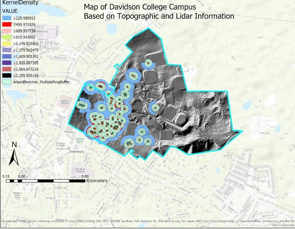
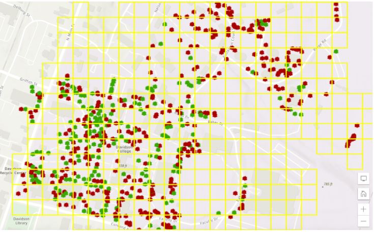
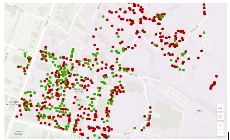
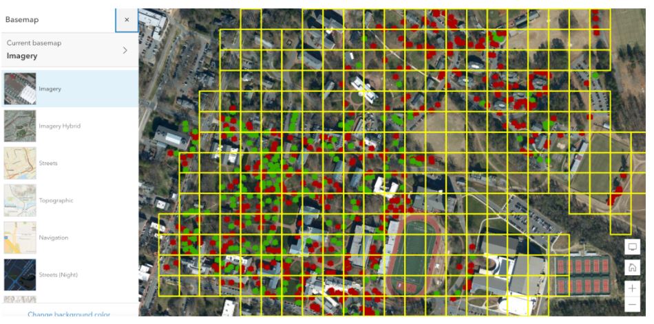
The Davidson arboretum is significant for several reasons. First, trees play a large role in carbon sequestration, or keeping carbon dioxide out of the atmosphere. The arboretum also cools campus and creates shady areas. Finally, the diverse collection of trees represented help us study and preserve native and engaged species in our region. We created an ArcGIS map with the help of visiting assistant professor of anthropology Dr. Maxime Lamoureux-St-Hilaire. ArcGIS maps are primarily composed of a basemap and one or more layers of information. Our arboretum map includes two layers—a feature layer storing data points, each corresponding to a tree, and a grid to help us divide campus into useful 50 x 50 meter squares. See figures 1-4 for additional information on how ArcGIS layers and the basemap work together. 

 Figure 1: Arboretum map showing both the feature layer and grid layer. Green points represent tagged trees and red represent untagged.

Figure 2: Arboretum map with only the feature layer visible.
Figure 3: Arboretum map showing both feature layers turned off; only the basemap remains.
Figure 4: ArcGIS layers can be overlaid on a variety of preset basemaps which users can quickly toggle between. Users can also create their own basemap. 

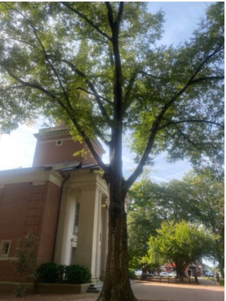
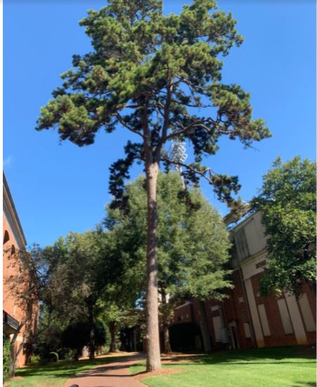
Students in Dr. Lamoureux-St-Hilaire’s fall 2021 Imaging the Earth class collected the majority of the data thus far using the ArcGIS Field Maps app. Each student spent a week in October recording data, collecting information on a tree’s location, whether or not it is tagged, whether the tree is coniferous or deciduous (see figs. 5 and 6), and the tree’s diameter at breast height (DBH, see fig. 7 at the top of the post). DBH is a simple but powerful dendrological measurement often used as a proxy for biomass and can be analyzed alongside height to approximate a tree’s carbon sequestration. Find a video demonstrating how to collect all these measurements at the end of this post. 

Figure 5: An example of a deciduous tree on campus. 
Figure 6: An example of a coniferous tree on campus.

After the initial census, Chloe and I started auditing individual grid squares (see fig. 1) to fill in any missing trees. This project is far from over; next semester Chloe and I will continue to audit the current data and identify trees without tags. We also plan to revisit previously collected points to update data the anthropology students didn’t collect, such as height and species. We’re hoping to involve additional members of the Davidson community with an interest in the arboretum. In future years, students can use the same map to collect new measurements for each tree, in order to continually update the online version of the map and compare data across years. 

Thank you to Dr. Lamoureux-St-Hilaire, Dr. Susana Wadgymar, and Chloe Fisher for all their help this semester. I look forward to continuing this project in the spring and setting up future lab members for even more exciting research. 

Video – “Collecting basic measurements using the ArcGIS Field Maps app” 

References 

Cottle, Jessica. “National Park and Recreation Month: Davidson College Arboretum.” Around the D: The Davidson College Archives & Special Collections blog (post), July 13, 2018. Accessed December 9, 2021. https://davidsonarchivesandspecialcollections.org/aroundthed/national-park-and-recreation-month-davidson-college-arboretum/.

Davidson, North Carolina 28035894-2000. “Arboretum.” Davidson. Accessed December 9, 2021. https://www.davidson.edu/offices-and-services/physical-plant/arboretum.

Dick, Lacy. “The Davidson College Arboretum: A Time Line | News of Davidson.” Accessed December 9, 2021. https://newsofdavidson.org/2018/07/29/7205/the-davidson-college-arboretum-a-time-line/.

“What Is a Geographic Information System (GIS)? | U.S. Geological Survey.” Accessed December 9, 2021. https://www.usgs.gov/faqs/what-geographic-information-system-gis.

Guest Blogger: Michaela Gibbons on “Dean Rusk: Dean Rusk’s Ideology”

At a young age, David Dean Rusk memorized the Westminster Shorter Catechism. Its main question, “What is the chief end of man?” is one that Rusk referred back to throughout his career. While this question—at its essence—asked about life’s purpose, Rusk considered how it can drive governments. Rusk thought governments must work to preserve our inalienable human rights in order to ensure the survival of the human race. From Rusk’s perspective, these rights were violated by communism. His generation, the Greatest Generation, was imbued with anti-communist views. Members of this cohort grew up during the First Red Scare, were the primary fighters in World War II, and began careers during the Second Red Scare. Rusk, in particular, feared the spread of communism as it actively denied people the freedom to choose. 

A young Dean Rusk wearing a military uniform

There was, however, the correct choice to make: democracy. In Rusk’s opinion, democracy was the finest form of government. While the term was not coined until later, Rusk’s ideology falls under neoliberalism. He wanted free market capitalism and that freedom to choose correctly to be available to everyone. Rusk explains:

The men and women of the developed and less developed nations are coming together, day by day, in a wide range of other human activities: scientific cultural, medical, civil and social action. The ties between them as fellow citizens of a common planet in an exciting century are becoming stronger. And they form an essential basis for progress toward the community of free nations. It is also playing that there are differences of view between developed and less developed countries within the free world. Notably, those arising from old colonial experiences. These differences have been disruptive at times, but they should not be exaggerated. We shall find as time goes on a widened area of community between the more industrialized and less industrialized peoples. A community based on a common desire for peace, a common dedication to the principles of independence and a free choice, a common commitment to the United Nations Charter.

Dean Rusk, Dean Rusk Evening Lecture, 47:04

Here, it is important to note Rusk’s desire for progress. He perceived democracy as fundamental to the advancement of the human race:

“To bring about a unified and independent Congo seems to us to be the only objective that offers a realistic chance for the advancement of the peoples of the Congo and for peace in Central Africa.”

Dean Rusk, Dean Rusk Evening Lecture, 26:25

After World War II, many feared that terrorizing institutions would grow in power again and threaten the human race. Rusk referred to terrorism as barbarism that hindered the world’s advancement. 

How do we make neoliberalism accessible to all global citizens? Rusk’s answer was collective security. The theory he credited as the key to world peace required the unification of Western countries against shared threats. Collective security proved difficult, particularly in the instance of Vietnam, but Rusk did not realize this until later in his career. In the Davidson College Fall Convocation of 1985, he reflects:

[America has] taken, as I mentioned earlier, almost 600,000 casualties and dead and wounded since the end of World War II, in support of collective security, and it has not been all that collective, we put up 90% of the non-Korean forces in Korea, 80% of the non-Vietnamese forces in Vietnam. So if my cousins down in Georgia say, look, if collective security is going to require 50,000 American dead every 10 years, and it’s not even collective, maybe it’s not a good idea.

Dean Rusk, Fall Convocation 1985, 56:48

Dean Rusk speaking at Davidson College

At this time in Rusk’s life where his political career was over, he had come to realize that collective security may not be the only strategy for peace. Earlier, however, he would have argued collective security was the solution and if it required the continued presence of Allied forces to ensure a nation’s independence then so be it. The idea was not unpopular, especially after World War II. Rusk’s ideology did not change, but the country’s did. Prior to the Vietnam War, America’s tendency to get involved was celebrated. It reaffirmed the country’s position as a world power; it maintained good international relations. A cultural shift came with the Silent Generation and Baby Boomers who argued the interests of other nations are not worth the loss of American lives. 

Rusk encourages us to reexamine the purpose of government as it should align with the purpose of humankind. He urges newer generations to protect humanity by unlocking the key to world peace. If it is not collective security that will unify countries in the common interest of man, then we must ask ourselves what will. In a world of differences, what are the similarities that will bridge international communities?

Digitization and transcription funded courtesy of the Dean Rusk Program for International Studies. This blog post was written by Michaela Gibbons ’22. To listen to these interviews, browse the Dean Rusk Collection in Digital Davidson.

Guest Blogger: Michaela Gibbons on “Dean Rusk: Rusk and the Media”

  Dean Rusk walking down Main St., Davidson.

While David Dean Rusk was often berated by the media, he proved able to separate his own experiences with newscasters as a political figure from the ones he experienced as an American citizen. News media was not only growing as a competitive industry but was also playing an increasingly important role in political affairs. Rusk, however, felt as if they fell short of their new responsibilities:

One problem I have is that the very answer given by the news media to the question ‘What is news?’ cannot help but give us a distorted picture of the real situation and the real world. For example, I can tell you with complete accuracy today that the overwhelming majority of international frontiers are peaceful [….] But if that is not your impression it is partly because agreement, normality, serenity are simply not newsworthy. 

Dean Rusk, Fall Convocation 1985, 1:05:17

News cycles more often than not emphasized unrest and upheaval. Rusk claims that about eighty percent of the work in the U.S. State Department goes unreported by the press as it is simply maintaining the good international relationships that have been in existence. 

Dean Rusk giving a press conference

News media rarely gave topics of international importance the space and time that was necessary to fully comprehend the stories told.

“All the limited column inches in a newspaper on the limited breathless moments on radio and television news. So you’re always snatching at fragments of problems which might require much more time to put into any context.”

Dean Rusk, Chapel Talk

These fragments — headlines and descriptors — force consumers to react instantaneously and form implicit attitudes. Rather than providing informative reports, news outlets began to construct their own evocative narratives to boost their ratings. Rusk was particularly critical of the ABC television network’s choice to broadcast a film depicting nuclear disaster in America without any disclaimer. On November 20, 1983, The Day After was viewed by over 100 million Americans, reinforcing the fear of an inevitable nuclear war. Rusk points out how careless ABC was to frame a dramatization as a prediction. He explains,

“I personally think that ABC has a duty to have one of its top newsman come on at the very beginning of that show, and remind us that we are put behind us 38 years as a nuclear weapon has been used, and that they can find no situation present in the world today, which seems to be pointing toward a nuclear war.” 

Dean Rusk, Fall Convocation 1985, 1:05:17

Regardless, Rusk had faith in the news media to educate the American people. He claims,

“I think that the American people are overtime far better informed, more accurately, and in broader context than the people of any other country I know about.”

Dean Rusk, Dean Rusk Speech – Atlanta, 38:15

Perhaps this confidence comes from knowing the threat of communism and believing in democracy. Today, however, Americans are generally suspicious of media sources, especially those that have an established political identity. The news media will have to reevaluate its content and delivery if it wants to reestablish its credibility as an educator of the American people.

Digitization and transcription funded courtesy of the Dean Rusk Program for International Studies. This blog post was written by Michaela Gibbons ’22. To listen to these interviews, browse the Dean Rusk Collection in Digital Davidson.

Guest Blogger: Michaela Gibbons on “Dean Rusk: Foundation of the Dean Rusk Program”

The Dean Rusk Program for International Studies, now known as the Dean Rusk International Studies Program, was started by Frontis Johnston while he was interim President of Davidson College. Inspired by David Dean Rusk’s confidence that a liberal arts education would make a “universal man,” the program was established to offer all students a breadth of global insight through “scholarships, professorships, travel, and much, much more.” In the international city of Atlanta on November 2, 1983, the Dean Rusk Endowment for International Studies nearly reached its halfway mark of their $1 million goal as the speeches were ending. Meanwhile, endowments in Dallas and Houston were already raising additional funds to meet the program’s 1989 goal of $10 million. The Dean Rusk International Studies Program was the first of its kind, particularly in the South. 1

Dean Rusk standing in front of a podium

On the surface, the program aimed to integrate international issues into the Davidson bubble. Program director and former ambassador Jack Perry worked closely with the faculty-led International Education Committee, which was integral in conceptualizing the program and its direction. While some global education existed in the college’s curriculum, Perry was determined to broaden its offerings, introducing Latin American, African, and Asian studies. Funding was provided to faculty interested in international travel and incorporating global topics into their courses across departments. It was imperative that these studies were not a school within, but an integral part of Davidson College. As the program aimed to reach every student, a diverse board, Dean Rusk Program Student Advisory Committee, was founded to represent the student body and their interests.

Dean Rusk speaking to students

Confronted with globalized differences and similarities, students would have the tools to reflect on their privilege and fight for liberty. In Rusk’s eyes, the values instilled in students by the college were fundamental to this program’s success. Hoping this work would start locally, the program cooperated with other offices on campus to expand their efforts into Charlotte, North Carolina. More ambitiously, the Rusk Program aspired to prepare students as future world leaders. In Atlanta, it was dictated:

“Equip them with a world related knowledge, equip them with a global thinking perspective, and to equip them with a multinational understanding with a multi-cultural appreciation and with a multilingual capability.” 

Speaker 2, Dean Rusk Speech – Atlanta, 37:02.

 Dean Rusk Program in International Studies inaugural program

The Rusk Program collaborated with other offices, programs, and universities “To give each student, first, an informed awareness of our whole planet, and second, direct knowledge of at least one foreign area.”2 While the first half of the mission became achievable on campus, the second half encouraged students to think beyond the small college town. Study abroad opportunities began in 1968, but with the Rusk Program’s support, it grew substantially. President John Kuykendall lauded:

A key aspect of our program both in the immediate past and for the foreseeable future has been the development of programs in conjunction with colleges and universities abroad. Our term abroad and junior year abroad programs currently provide remarkable experiences for personal growth to at least one of every four Davidson students.

John Kuykendall, Fall Convocation 1985, 0:00

Junior Year Abroad provided a unique opportunity for cultural immersion in countries, such as Germany and France at first and then across Europe, South America, and Southern Asia. This aspect of the Rusk Program has grown immensely in student participation and has granted Davidson College an international identity in higher education. Dean Rusk was enthusiastic about this program’s potential and was confident in its excellence. He urged program administrators to stay true to Davidson’s liberal arts identity while developing its global consciousness.3

Works Cited:

  1.  Dean Rusk, Dean Rusk Speech – Atlanta, 11:46. Speaker 2, Dean Rusk Speech – Atlanta, 30:35.
  2. Printed Material – Davidson College – Dean Rusk Program. 1989 – 1990. DC004. Dean Rusk Collection. Davidson College Archives, Davidson College, NC.
  3. History File, 1981 – 1983. 1981 -1983. RG 3/6.1. Dean Rusk Program. Davidson College Archives. Davidson College, NC.

Digitization and transcription funded courtesy of the Dean Rusk Program for International Studies. This blog post was written by Michaela Gibbons ’22. To listen to these interviews, browse the Dean Rusk Collection in Digital Davidson.

“(Re)Collecting COVID-19: Davidson Stories” Week One Update

As mentioned in the previous blog post about the 1918 Spanish flu epidemic, Archives and Special Collections is proud to present the initiative “(Re)Collecting COVID-19: Davidson Stories.” In this crowdsourcing project, we aim to document the personal experiences of students, faculty, staff, alumni, and community members during the COVID-19 epidemic. We invite you to share your COVID-19 story through the contribution of original words, music, video, art, or images, regardless of whether you are on campus, in the Town of Davidson, or thousands of miles away.

We’ve had a wonderful start to this project and here are some highlights of the first contributions!

Wearing face masks to go outside and to go shopping has become the temporary new normal. Many people are wearing homemade masks as seen by contributions from Annelise Gorensek-Benitez (Visiting Assistant Professor of Chemistry), Molly Kunkel (Digital Archivist; “Shopping Essentials”), and Ann Haley and Shaw Smith (Joel O. Conarroe Professor of Art History).

We are also delighted to see contributions of creative works, including a painting from community member Dr. Edward L. Boye and original poetry from Lisa Forest (Leland M. Park Director of E.H. Little Library) and Anthony S. Abbott (Professor of English Emeritus).

Painting of castle.
“Finding Your Castle” by Dr. Edward L. Boye

A huge thank you to those who have submitted thus far! If you would like to view more contributions or would like to contribute an item to the “(Re)Collecting COVID-19: Davidson Stories,” please visit the site.

(Re)Collecting the Spanish Influenza Epidemic of 1918 and COVID-19 in Davidson

On September 18, 1918, the fall term of the 1918-1919 academic year began at Davidson. Three weeks later on October 9, 1918, The Davidsonian reported that the college experienced “a severe visitation” of Spanish influenza. From the report of the first case, new cases began to emerge rapidly. The infirmary, although equipped with medical equipment and staff, quickly became overrun with patients. To more adequately attend to the sick, the Chambers building, the main academic building on campus (which also had two wings set aside as dormitories), was turned into a makeshift hospital. At first, only the first floor of the south wing was used to house the sick. However, cases continued to appear and the second and third floors of the wing were quickly repurposed as hospital wards (“‘Flu’ Epidemic Takes Heavy Toll at Davidson”).

Chambers as built.
Old Chambers (Burned in 1921)

With an ever-increasing volume of cases, campus administration decided to suspend class for three weeks and to place campus under quarantine. To care for the sick, the entire Davidson community offered support. Nurses attended to the ill, the women of the Davidson Red Cross Chapter provided meals and necessary supplies, and Davidson professors took regular shifts to assist in any way they could. One individual, presumably a student (and possibly one of those infirmed) remarked about this extraordinary support offered by the community in the October 9, 1918 Davidsonian (“Editorial”).

The Davidsonian, October 9, 1918

These combined efforts worked. Remarkably, the next issue of The Davidsonian (October 23, 1918), reported that after three weeks of cases of the Spanish flu on campus, the epidemic was practically over. In total, over 200 cases of the flu were reported and those remaining were rapidly recovering (“‘Flue’ Has Vanished From Davidson College”). However, one student, Daniel J. Currie of Defuniac Springs, Florida, did pass away from pneumonia, which was likely resultant from the influenza. Nurse Laura Rose Stevenson of Charlotte treated patients at Davidson and also died of pneumonia (“In Memoriam”).

While the college was rocked by the flu, the Town of Davidson was as well. The sick were treated in their homes, cotton mills and schools temporarily shut down, and the town was placed under quarantine. The October 23, 1918 issue of The Davidsonian included notices of townspeople affected by the influenza (“Town Items”).

The Davidsonian, October 23, 1918

Like in the case of the college, the Red Cross provided assistance to the Town of Davidson. In total, over 150 cases were reported in the town. There were at least five deaths from pneumonia, most of which were African American (“‘Flu’ Situation in Town Is Now Much Improved”). The next week, in the November 6, 1918 Davidsonian, it is reported that the town’s quarantine had been lifted and that mills had resumed work (“‘Flu Situation In Town Continues to Improve).

Although the events of the Spanish flu epidemic occurred over 100 years ago, we find ourselves in a very similar situation today with COVID-19. What can we learn by reflecting on Davidson’s response to the Spanish flu?

I think it is this: It takes all of us to get through it. In 1918, this was evident in medical personnel, townspeople, and the college community coming together to help one another. In 2020, we can see the same thing occurring. We are helping each other by tending to the ill, by donating supplies, by abiding stay-at-home orders, by offering each other emotional support. The list goes on and on. We are all trying our best to help each other get through it. And I think that is worth everything.

As Davidson adjusts to the COVID-19 pandemic, we are challenged to develop new ways to engage and interact with our community. Davidson College Archives, Special Collections & Community, which regularly collects, shares, and preserves the college’s and community’s unique stories, would like to document the experiences of students, faculty, staff, alumni, and community members during these uncertain times. To this end, we are excited to present our initiative “(Re)Collecting COVID-19: Davidson Stories.” In this crowdsourcing project, we invite you to share your COVID-19 story through the contribution of original words, music, video, art, or images, regardless of whether you are on campus, in the Town of Davidson, or thousands of miles away. To learn more about “(Re)Collecting COVID-19: Davidson Stories, please visit the site.

Works Cited

“Editorial.” The Davidsonian, [Davidson, NC], 9 Oct. 1918, p. 2, library.davidson.edu/archives/davidsonian/PDFs/19181009.pdf.

“‘Flu’ Epidemic Takes Heavy Toll at Davidson.” The Davidsonian, [Davidson, NC], 9 Oct. 1918, p. 1, library.davidson.edu/archives/davidsonian/PDFs/19181009.pdf.

“‘Flu’ Situation In Town Continues to Improve.” The Davidsonian, [Davidson, NC], 6 Nov. 1918, p. 1, library.davidson.edu/archives/davidsonian/PDFs/19181106.pdf.

“‘Flu’ Situation in Town Is Now Much Improved.” The Davidsonian, [Davidson, NC], 30 Oct. 1918, p. 1, library.davidson.edu/archives/davidsonian/PDFs/19181030.pdf.

“‘Flue’ Has Vanished From Davidson College.” The Davidsonian, [Davidson, NC], 23 Oct. 1918, p. 1, library.davidson.edu/archives/davidsonian/PDFs/19181023.pdf.

“In Memoriam.” The Davidsonian, [Davidson, NC], 23 Oct. 1918, p. 2, library.davidson.edu/archives/davidsonian/PDFs/19181023.pdf.

Guest bloggers: Elise Edman and Dan Murphy, “How Mapping Davidson’s Campus Altered Students’ Perceptions of Campus”

Elise Edman is a senior Computer Science major, Data Science minor, and has just finished her last volleyball season at Davidson. Next year, she will be working in St. Louis, MO as a Systems Engineer for the Cardinals.

Dan Murphy is a junior Economics major, Data Science minor, and Data CATs consultant in the Hurt Hub. This summer, he will be working in Denver, Colorado designing, developing, and testing algorithms for darknet data at DarkOwl Cybersecurity.

In October of 2019, the students of Dr. Maxime Lamoureux-St-Hilaire’s course, Imaging the Earth (ANT 377), collectively mapped Davidson College’s campus. Using the “Collector for ArcGIS” app (available for download in Apple’s App Store), students walked around campus to collect the coordinates and other attributes of features like trash, garbage bins, trees, benches, art, honored objects (objects left alone and not stolen), and events. With this collaborative dataset, students were then tasked with using ArcGIS Pro software to create maps of Davidson’s campus with these features. This project ultimately changed the way that some students view the campus’ features and layout.

            One map that students created displays garbage bins with rings located 10, 20, and 40 meters away from the garbage bins’ coordinates (Map 1). The rings function to demonstrate the garbage bins’ proximity to each other and to trash found throughout campus. The map also features a representation of trash density on campus, where the darkest color is the area where trash is the densest. Most of the garbage bins and trash are found in the most student-frequented areas of campus, which is logical. It is interesting that the area with the densest trash is an area with plenty of garbage bins available to use. It appears that the distribution of garbage bins throughout campus is designed appropriately, but that students are not using them responsibly.

color map of the Davidson campus showing the location of garbage bins and loose trash

Map 1. Displays the distribution of garbage bins (with multiple ring buffers) and trash (with kernel density) throughout Davidson College’s campus.

            Another map that students created displays the benches around Davidson’s campus with rings located 15, 30, and 45 meters away from the benches’ coordinates (Map 2). In this context, the rings demonstrate the proximity of benches to other benches and artwork around campus. Students also used kernel density to analyze the density of benches and artwork throughout campus. As seen in Map 2’s legend, the red coloring represents the densest area of benches and artwork. The blue shading represents less densely-populated areas. The densest areas for benches and artwork on campus are near Chambers, Union, and the library. This is logical, as prospective students spend most of their time touring campus around these three spots. To make the campus visually attractive to visitors, it is logical that artwork and benches would be clustered in areas where they will be seen the most. Furthermore, there are additional dense areas behind the football field and near Baker Sports Complex. It appears that Davidson would do this to draw visitors to well-known on-campus locations.

color topographic map of the art and benches on the Davidson campus
Map 2. Displays the kernel density of art and benches and the distribution of benches (with multiple ring buffers).

            Overall, this project was a valuable experience for many students in Dr. Lamoureux-St-Hilaire’s “Imaging the Earth” course. It challenged our previous perceptions of Davidson’s campus, forcing us to be more analytical about our surroundings and to think deeper about the decisions that Davidson administrators and students make. Additionally, this project helped students gain a better understanding of ArcGIS Pro geoprocessing tools (like multiple ring buffer and kernel density tools), formatting maps, and creating map PDFs that are ready to be shared with others. Through this valuable learning experience, students gained important skills necessary for performing accurate, comprehensible, geographical research and presenting it to others.

Guest Blogger: Dr. Maxime Lamoureux-St-Hilaire Visiting Assistant Professor, Anthropology, “Collaborative Mapping at Davidson through GIS”

Dr. Lamoureux-St-Hilaire is an archaeologist specializing in ancient political systems and geoarchaeology. His research is centered on the Classic Maya world, where he’s worked in Mexico, Guatemala, Belize, and Honduras. For over a decade, his work has involved map-making and Geographic Information System (GIS). This summer, he’ll be taking Davidson students to Mexico and Belize to do some fieldwork. Dr. Max also co-organizes the Maya at the Lago Conference, and the 10th installment will take place at Davidson in late April.

Teaching an introductory course for Geographic Information System (GIS) comes with its set of challenges. You must teach how to operate one of the most complex software programs – ESRI’s ArcGIS Pro – while also teaching about a thoroughly interdisciplinary discipline to students majoring in diverse fields. This past semester, for the ANT-377 Imaging the Earth course, I decided to emphasize a few key topics including (1) how to ask questions about landscapes; (2) how to tie complex datasets to diverse landscapes; (3) how to create clear maps to answer these questions; and (4) how to adequately report this scientific inquisitive process.

                The best way to learn a scientific process is to learn it from beginning to end. In the case of GIS, this begins with collecting data – something that used to require a fairly complex technological setup – e.g., high resolution GPS, total station, etc. Thankfully, the new ArcGIS Pro software comes with a sister app, Collector, which uses your phone’s GPS to take datapoints. After designing a database, I asked the students to roam the Davidson campus to collect basic information about trees, benches, garbage bins, trash, art, and “honored object” (i.e., objects left lying around by students because of the honor code). Over the course of three weeks, the 16 students and myself recorded the GPS location and basic information (characteristics, height, etc.) of 447 features on campus.

Screen shot of cell phone rendering  Davidson campus with colored icons representing activities in specific places
Figure 1. The Collector App uses your phone’s GPS to identify the location of features. The highlighted “Honored Object” feature was a backpack left in a hallway of the north basement of Chambers during a class on Oct 7, 2019.

This process gave the entire group the opportunity to create an original dataset from scratch, which was then available for analysis and reporting (later this week, look for the companion blog entry by Edman and Stearns). Using opensource Lidar data for Mecklenburg County, I asked students to project these features onto a detailed Digital Elevation Model (DEM) of the Davidson Campus. These combined tasks led students to autonomously combine vector (the geodatabase) and raster (the DEM) GIS data – the two types of datasets handled by GIS specialists.

                Using Collector to create a basic geodatabase effectively led students to appreciate their campus from a GIS angle. In addition, the following steps of this exercise allowed them to apply analytical and technical display techniques learned in class to their collaborative dataset. This project was their great first foray into the GIS process, which paved the way to their own personal projects; all of which involved far larger datasets generally obtained online.

A colored map of Davidson campus using the online platform of ESRI to visualize queries

Figure 2. In addition to Collector and ArcGIS Pro, ESRI has an online platform – arcgis.com – which allows you to visualize, query, and modify some of your maps and to produce simple displays such as this one.

                 GIS technology is challenging because of the thousands of disciplines it is used for, from archaeology and engineering to agriculture and military science. Yet, this exercise proved to be an excellent pedagogical tool to allow students to familiarize themselves with each step involved in the creation of a geodatabase, its analysis, rendering, and presentation. Developing this exercise (especially adequately setting up the database) was also a learning process for me, and I’m excited to continue developing this exercise in the future. Instead of 447 features, I hope to reach 1,000 in next fall’s iteration of this exercise for Imaging the Earth. In particular, I hope to study in more details the distribution of “honored objects”, which reflect a rich idiosyncratic dimension of Davidson’s academic life.

A year of Digital Humanities and the Davidson archives

This week’s post is written by Dr. Anelise H. Shrout, a Mellon Postdoctoral Fellow in Digital Studies.

Over the past two semesters, I’ve had the privilege of trying out some new course ideas that blended digital humanities and archival work. The challenge of bringing #dh into archives and archives into #dh is that it can actually be quite a chore to translate historical data – as transcribed in minute books, maps, or letters – into a form that works for #dh visualizations and research. This year, I had two students whose projects used “analog” material from the Davidson Archives to create interesting and captivating digital artifacts, each of which showcased something new about Davidson history. These projects speak for themselves, but I thought I’d say a little about the process that each undertook to get from poring over manuscripts in the rare books room to these digital explorations of Davidson’s past.

Mapping Davidson’s Environmental History

Sarah Roberts, a senior Environmental Studies major, undertook the impressive task of charting Davidson’s environmental development over time. Using maps like this one:

1983-84 campus shrub map.

1983-84 campus shrub map.

– and many more besides, she created a series of visualizations that documented different aspects of Davidson’s environmental history at different points in time. This was not an easy process. For each of the maps she used, she had to trace the outlines of important features (buildings, athletics fields, a briefly-present lake) and color code them according to their purpose.

She brought all of these together in an environmental studies capstone project, but also in a dynamic website which takes users through the spatial history of Davidson College and a bit of the town.

Screenshot of Sarah Roberts' site

Screenshot of Sarah Roberts’ project site.

Mapping Davidson’s Institutional History

Avery Haller, a senior anthropology major also used the Davidson archives, but instead of tracking Davidson’s spatial history, she was interested in the college’s social and institutional history. Avery used the minutes of the Concord Presbytery, the Presbyterian group which was prompted by “the closing of Liberty Hall Academy (now Washington and Lee University) due to a massive fire” to found “a new place close to home to send their young men to school.”

Using documents like this one (which, happily, were transcribed):

Concord Presbytery Minutes-March 1835.

Concord Presbytery Minutes-March 1835.

Avery was able to extract social networks – the ties that bound the various men (and they were all men) involved in Davidson’s founding together (She describes the technical part of this process here).

The finished network with its origin being R.H. Morrison the first Davidson College President who is in darker green

The finished network – the first Davidson College President, Robert Hall Morrison, is in darker green.

Ultimately, Avery concluded that both a close reading of the sources and a systematic analysis of connections among Davidson’s founders revealed “a picture of Davidson … that blend[ed] conservative values and an entrepreneurial spirit.”

Together, these projects point to the innovative work that can emerge when traditional historical materials are deployed in new ways. However, both of these projects took an extraordinary amount of time to accomplish – since before they could begin their analysis, both Avery and Sarah had to render historical “data” legible for digital tools. As one student noted in my class’s final presentations “As most of you have found, data entry is kind of tedious,” but I hope that these projects can help convince students and researchers alike that the intersection of #dh and archives can lead to some fruitful and interesting results.

Digital Mapping at the Davidson Archives

Inspired by the newly-established campus Digital Mapping Learning Community, we’ve been creating more digital map-related resources this semester. Regular Around the D readers have likely heard of Under Lake Norman, our mapping project that includes crowdsourced stories and images related to what lies beneath Lake Norman.

A screenshot of the Under Lake Norman project's map on google maps with geo markers

A screenshot of the Under Lake Norman project’s map – you can see all of the sites under the lake here, and share stories or add sites here.

One of our faculty members, Dr. Anelise Hanson Shrout (who wrote a guest post for Around The D last year), has been creating mapping projects centered around Davidson, and taught DIG 360: Digital Maps, Space and Place last semester, which resulted in two student digital mapping of Davidson projects as well. Check out Dr. Shrout’s Mapping Davidson’s Past project on her website.

A screenshot of a HistoryPin tour of Main Street that Dr. Shrout created.

A screenshot of a Historypin tour of Main Street that Dr. Shrout created.

Last week, in preparation for the Archives & Special Collections participation in Digital Charlotte, I created a map of the Charlotte locations featured in our collections postcards. The Charlotte Postcards maps is actually my first Neatline (an Omeka plug-in) project, and was a fun way to learn more about early 20th century Charlotte history.

Charlotte postcard locations, 1900 - 1920 - Davidson has roughly 20 postcards featuring Charlotte locations in our collections.

Charlotte postcard locations, 1900 – 1920 – Davidson has roughly 20 postcards featuring Charlotte locations in our collections.

As we all learn new methods for digital mapping, we’ll be creating even more maps of Davidson (and the surrounding area)! Currently, College Archivist and Records Management Coordinator Jan Blodgett and Kyle Goodfellow from the Center for Civic Engagement are working on translating the freshman orientation community walk to an interactive map,  making the stops along the walk and information about getting involved in the Davidson community available year-round. Current student Sarah Roberts (Class of 2015) is working on physically mapping the environment of Davidson, and I am partway through mapping Davidson’s National Register of Historic Places sites – look out for all of these projects to be linked on the Archives & Special Collections website when they’re completed!